Home > Maps and Charts > Early Maps
Jigsaw Puzzle : Roman Britain Map


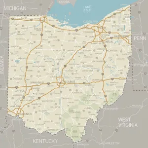
![]()
Jigsaw Puzzles from Mary Evans Picture Library
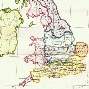
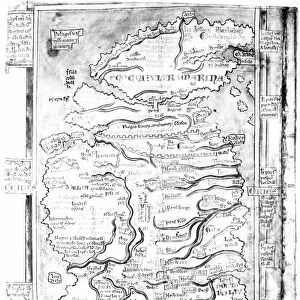
Roman Britain Map
A map depicting the network of Roman settlements in Britain
Mary Evans Picture Library makes available wonderful images created for people to enjoy over the centuries
Media ID 7179027
© Mary Evans Picture Library 2015 - https://copyrighthub.org/s0/hub1/creation/maryevans/MaryEvansPictureID/10510851
Latin Net Work Settlements Tribes
Jigsaw Puzzle (252 Pieces)
Discover the rich history of Roman Britain with our captivating Jigsaw Puzzles from Media Storehouse. This intricately detailed puzzle features a stunning map of Roman settlements in Britain, sourced from Mary Evans Prints Online. Immerse yourself in the past as you piece together the network of ancient Roman towns, forts, and villas. A perfect activity for history enthusiasts, families, or anyone seeking a challenging and rewarding puzzle experience. Engage your mind, unwind, and bring the past to life with Media Storehouse Jigsaw Puzzles.
Made in the USA, 252-piece puzzles measure 11" x 14" (27.9 x 35.5 cm). Every puzzle is meticulously printed on glossy photo paper, which has a strong 1.33 mm thickness. Delivered in a black storage cardboard box, these puzzles are both stylish and practical. (Note: puzzles contain small parts and are not suitable for children under 3 years of age.)
Jigsaw Puzzles are an ideal gift for any occasion
Estimated Product Size is 28cm x 35.6cm (11" x 14")
These are individually made so all sizes are approximate
Artwork printed orientated as per the preview above, with portrait (vertical) orientation to match the source image.
EDITORS COMMENTS
1. Title: "Roman Britain: A Network of Settlements and Tribes" This map print transports us back in time to the ancient world of Roman Britain, a period marked by the expansion of the Roman Empire and the establishment of a complex network of settlements and tribes. The intricate details of this map, sourced from Mary Evans Prints Online, offer a fascinating glimpse into the geographical distribution of Roman influence in Britain during the 1st to 4th centuries AD. The Latin inscriptions on the map label various Roman towns, fortifications, and rivers, providing valuable insights into the Roman administrative system and the strategic locations of their settlements. The map also highlights the territories of several prominent British tribes, such as the Iceni, the Silures, and the Dumnonii, demonstrating the intricate web of relationships between the Romans and the native population. The Roman conquest of Britain began in 43 AD, and over the next several centuries, the Romans built an extensive network of roads, forts, and towns that connected different parts of the island. This map serves as a testament to the remarkable engineering and organizational skills of the Romans, as well as their ability to adapt to new environments and integrate diverse cultures. The map is not only an essential resource for historians and archaeologists but also a beautiful work of art that showcases the rich history and cultural exchange between the Roman Empire and Britain. Whether displayed in a museum, a library, or a private collection, this map print is sure to captivate the imagination and inspire a deeper appreciation for the complexities of ancient civilizations.
MADE IN THE USA
Safe Shipping with 30 Day Money Back Guarantee
FREE PERSONALISATION*
We are proud to offer a range of customisation features including Personalised Captions, Color Filters and Picture Zoom Tools
FREE COLORIZATION SERVICE
You can choose advanced AI Colorization for this picture at no extra charge!
SECURE PAYMENTS
We happily accept a wide range of payment options so you can pay for the things you need in the way that is most convenient for you
* Options may vary by product and licensing agreement. Zoomed Pictures can be adjusted in the Cart.