Home > Animals > Mammals > Soricidae > Navigator
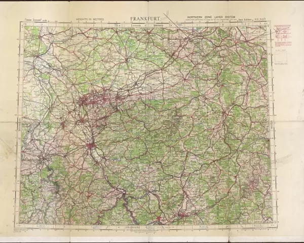
Canvas Print : RAF navigators map of Frankfurt


![]()
Canvas Prints from Mary Evans Picture Library
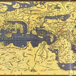
RAF navigators map of Frankfurt
Ordance survey map of Germany around Frankfurt, showing the location of Cologne (Koln), Koblenz, Frankfurt and other towns and cities in the area, compiled and drawn at the War Office. The map was used by RAF navigators on bombing raids
Mary Evans Picture Library makes available wonderful images created for people to enjoy over the centuries
Media ID 4478665
© Mary Evans Picture Library 2015 - https://copyrighthub.org/s0/hub1/creation/maryevans/MaryEvansPictureID/10439027
1942 Bombers Bombing Cologne Frankfurt Koblenz Koln Maps Navigator Navigators Raid Raids Survey Ww 2 Ww Ii Bomber
20"x16" (51x41cm) Canvas Print
"Bring history into your home with our stunning RAF Navigators Map of Frankfurt Canvas Print from Media Storehouse. This unique piece, sourced from Mary Evans Prints Online, showcases an Ordance Survey map of Germany around Frankfurt, compiled and drawn at the War Office. With intricate details and a rich historical context, this canvas print is perfect for aviation enthusiasts, history buffs, or anyone looking to add a touch of nostalgia to their decor. The high-quality canvas material enhances the vibrant colors and fine details of the map, making it a captivating conversation starter in any room. Order yours today and embark on a journey through time with this exceptional piece of art."
Delivered stretched and ready to hang our premium quality canvas prints are made from a polyester/cotton blend canvas and stretched over a 1.25" (32mm) kiln dried knot free wood stretcher bar. Packaged in a plastic bag and secured to a cardboard insert for safe transit.
Canvas Prints add colour, depth and texture to any space. Professionally Stretched Canvas over a hidden Wooden Box Frame and Ready to Hang
Estimated Product Size is 50.8cm x 40.6cm (20" x 16")
These are individually made so all sizes are approximate
Artwork printed orientated as per the preview above, with landscape (horizontal) orientation to match the source image.
FEATURES IN THESE COLLECTIONS
> Animals
> Mammals
> Soricidae
> Navigator
> Historic
> World War I and II
> World War II
> Maps and Charts
> Early Maps
> Maps and Charts
> World
EDITORS COMMENTS
This historic photograph depicts an Ordnance Survey map of the Frankfurt region in Germany, compiled and drawn at the War Office during World War II. The map, which dates back to 1942, provides a detailed and intricate representation of the area surrounding Frankfurt, including the locations of Cologne (Koln) and Koblenz. During the intense aerial campaigns of World War II, RAF navigators relied on maps like this one to guide their bombing raids over enemy territory. The map's precise and meticulous details would have been essential for navigators as they planned their routes and targeted specific areas with bombs. The map's title, "Frankfurt on the Main and Surrounding Areas," is written in bold letters at the top, with a scale of 1:250,000 and the year of publication, 1942, noted at the bottom. The map's intricate details include roads, railways, bodies of water, and the locations of towns and cities, all rendered in crisp, clear lines. The map's historical significance is underscored by the context of its creation. The RAF's bombing campaigns during World War II were a pivotal part of the Allied effort to weaken the German war machine and ultimately bring about its defeat. Navigators like those who used this map played a crucial role in these campaigns, risking their lives to deliver bombs to their targets with precision and accuracy. This photograph is a poignant reminder of the vital role that maps played in the history of military aviation and the strategic planning of bombing raids during World War II. The intricate details of this Ordnance Survey map of Frankfurt and its surrounding areas offer a glimpse into the meticulous planning and execution of these historic military operations.
MADE IN THE USA
Safe Shipping with 30 Day Money Back Guarantee
FREE PERSONALISATION*
We are proud to offer a range of customisation features including Personalised Captions, Color Filters and Picture Zoom Tools
SECURE PAYMENTS
We happily accept a wide range of payment options so you can pay for the things you need in the way that is most convenient for you
* Options may vary by product and licensing agreement. Zoomed Pictures can be adjusted in the Cart.