Home > Maps and Charts > World
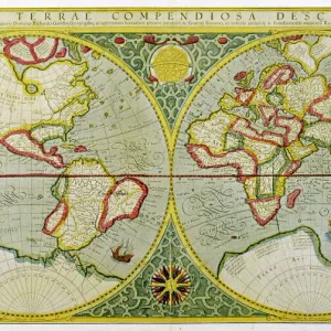
Canvas Print : Overton World Map / 1670


![]()
Canvas Prints from Mary Evans Picture Library
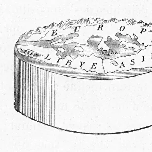
Overton World Map / 1670
A new and accurate map of the world drawn according to the best and late discoveries of 1670
Mary Evans Picture Library makes available wonderful images created for people to enjoy over the centuries
Media ID 592680
© Mary Evans Picture Library 2015 - https://copyrighthub.org/s0/hub1/creation/maryevans/MaryEvansPictureID/10041717
1670 Accurate Best Discoveries Drawn Maps Overton
20"x16" (51x41cm) Canvas Print
Introducing the captivating "Overton World Map / 1670" from our Media Storehouse Canvas Print collection, brought to you by Mary Evans Picture Library via Mary Evans Prints Online. This exquisite piece showcases an intricately detailed and accurate representation of the world as it was known in 1670. Each line and border on this vintage map tells a story of exploration and discovery, making it a fascinating addition to any home or office decor. Our high-quality canvas prints are meticulously crafted to bring out the rich colors and intricacies of this historical masterpiece, ensuring a stunning and timeless piece that will captivate and inspire for years to come.
Delivered stretched and ready to hang our premium quality canvas prints are made from a polyester/cotton blend canvas and stretched over a 1.25" (32mm) kiln dried knot free wood stretcher bar. Packaged in a plastic bag and secured to a cardboard insert for safe transit.
Canvas Prints add colour, depth and texture to any space. Professionally Stretched Canvas over a hidden Wooden Box Frame and Ready to Hang
Estimated Product Size is 50.8cm x 40.6cm (20" x 16")
These are individually made so all sizes are approximate
Artwork printed orientated as per the preview above, with landscape (horizontal) orientation to match the source image.
FEATURES IN THESE COLLECTIONS
> Maps and Charts
> Early Maps
> Maps and Charts
> Related Images
> Maps and Charts
> World
> Mary Evans Prints Online
> Maps
EDITORS COMMENTS
This stunning print of the Overton World Map from 1670 offers a fascinating glimpse into the historical cartography of the late 17th century. Drawn according to the best and latest discoveries of its time, this map provides an accurate representation of how people viewed the world over 350 years ago.
The intricate details and careful craftsmanship that went into creating this map are truly remarkable, showcasing both the artistry and scientific knowledge of early mapmakers. From coastlines to continents, every feature is meticulously drawn with precision and care.
As we study this map, we can't help but marvel at how much our understanding of geography has evolved since then. The boundaries may have shifted, new lands may have been discovered, but this snapshot in time remains a valuable piece of history that allows us to appreciate how far we've come.
Whether you're a history buff, a lover of maps, or simply someone who appreciates beautiful artwork, this print is sure to captivate your imagination and spark your curiosity about the world as it was seen centuries ago. It's a reminder that even as technology advances and our knowledge grows, there will always be something magical about holding a piece of history in your hands.
MADE IN THE USA
Safe Shipping with 30 Day Money Back Guarantee
FREE PERSONALISATION*
We are proud to offer a range of customisation features including Personalised Captions, Color Filters and Picture Zoom Tools
SECURE PAYMENTS
We happily accept a wide range of payment options so you can pay for the things you need in the way that is most convenient for you
* Options may vary by product and licensing agreement. Zoomed Pictures can be adjusted in the Cart.