Home > Europe > United Kingdom > England > County Durham > Durham
Canvas Print : Northern Road Newcastle


![]()
Canvas Prints from Mary Evans Picture Library
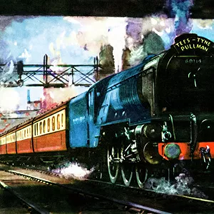
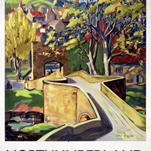
Northern Road Newcastle
A plan of the road heading north from Durham through Newcastle and further northwards through other towns in Northumberland
Mary Evans Picture Library makes available wonderful images created for people to enjoy over the centuries
Media ID 4348857
© Mary Evans Picture Library 2015 - https://copyrighthub.org/s0/hub1/creation/maryevans/MaryEvansPictureID/10185816
Crest Distance Durham Heading Hills New Castle North Umberland Northwards Plan Roads Route Towns
20"x16" (51x41cm) Canvas Print
"Experience the rich history and beauty of Northern England with our stunning Canvas Print of "Northern Road Newcastle" by Mary Evans Prints Online. This captivating image takes you on a journey north from Durham through Newcastle, exploring the picturesque towns of Northumberland. Our high-quality Canvas Prints are meticulously crafted with vibrant colors and fine details, bringing the charm of this iconic road right into your home or office. Order now and let the adventure begin!"
Delivered stretched and ready to hang our premium quality canvas prints are made from a polyester/cotton blend canvas and stretched over a 1.25" (32mm) kiln dried knot free wood stretcher bar. Packaged in a plastic bag and secured to a cardboard insert for safe transit.
Canvas Prints add colour, depth and texture to any space. Professionally Stretched Canvas over a hidden Wooden Box Frame and Ready to Hang
Estimated Product Size is 40.6cm x 50.8cm (16" x 20")
These are individually made so all sizes are approximate
Artwork printed orientated as per the preview above, with portrait (vertical) orientation to match the source image.
FEATURES IN THESE COLLECTIONS
> Europe
> United Kingdom
> England
> County Durham
> Durham
> Europe
> United Kingdom
> England
> Durham
> Durham
> Europe
> United Kingdom
> England
> Northumberland
> Related Images
> Europe
> United Kingdom
> Heritage Sites
> Durham Castle and Cathedral
> Europe
> United Kingdom
> Northern Ireland
> County Down
> Newcastle
> Maps and Charts
> Early Maps
EDITORS COMMENTS
This print showcases a historical map titled "Northern Road Newcastle," offering a detailed plan of the road heading north from Durham through Newcastle and further northwards through other towns in Northumberland. The late 18th-century map provides a fascinating glimpse into the transport routes and infrastructure of the time, highlighting key landmarks such as new castle, crest, general, road, county, route, distance, hills, roads, towns, and streets.
The intricate details on this map offer valuable insights into the history and development of Northern England during this period. From bustling town centers to winding country roads cutting through picturesque landscapes, this map captures the essence of travel in Northumberland and Durham centuries ago.
As we study this historical document closely, we can imagine the hustle and bustle of travelers making their way along these roads on horseback or by carriage. Each town marked on the map tells its own story of trade and commerce that once thrived along this important northern route.
Overall, this print is not just a visual representation but also a window into the past that allows us to appreciate how far transportation has come since then. It serves as a reminder of our rich heritage and how interconnected our communities have always been throughout history.
MADE IN THE USA
Safe Shipping with 30 Day Money Back Guarantee
FREE PERSONALISATION*
We are proud to offer a range of customisation features including Personalised Captions, Color Filters and Picture Zoom Tools
SECURE PAYMENTS
We happily accept a wide range of payment options so you can pay for the things you need in the way that is most convenient for you
* Options may vary by product and licensing agreement. Zoomed Pictures can be adjusted in the Cart.