Home > Europe > Netherlands > Lakes > IJsselmeer
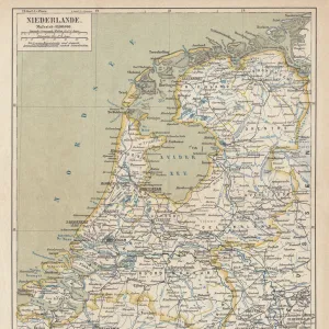
Netherlands, Relief Map With Border and Mask

![]()
Wall Art and Photo Gifts from Universal Images Group (UIG)
Netherlands, Relief Map With Border and Mask
Relief map of Netherlands (with border and mask). This image was compiled from data acquired by landsat 5 & 7 satellites combined with elevation data
Universal Images Group (UIG) manages distribution for many leading specialist agencies worldwide
Media ID 9612947
© Planet Observer/UIG
Amsterdam Coastline Holland Netherlands North Sea Relief Map Rotterdam Shore Ijsselmeer Polders Satellite View The Hague Wadden Sea
FEATURES IN THESE COLLECTIONS
> Aerial Photography
> Netherlands
> Europe
> Netherlands
> Amsterdam
> Europe
> Netherlands
> The Hague
> Europe
> Netherlands
> Heritage Sites
> Wadden Sea
> Europe
> Netherlands
> Lakes
> IJsselmeer
> Europe
> Netherlands
> Maps
> Europe
> Netherlands
> Rotterdam
> Universal Images Group (UIG)
> Universal Images Group
> Satellite and Aerial
> Planet Observer 4
EDITORS COMMENTS
This print showcases the stunning relief map of the Netherlands, complete with its intricate border and mask. Created using data acquired by landsat 5 & 7 satellites, combined with elevation data, this image offers a unique perspective on the physical geography of this beautiful European country. From the shores along the North Sea to the vibrant cities like Amsterdam and Rotterdam, every detail is meticulously captured in this vertical photograph. The topography of Holland comes to life as you explore its diverse landscapes, including the mesmerizing Wadden Sea and picturesque Ijsselmeer. With no people in sight, this color image allows us to focus solely on appreciating the natural beauty and man-made marvels that define the Netherlands. The polders, an iconic feature of Dutch engineering prowess, are also highlighted in this relief map. As we gaze upon this satellite view turned art piece, it's impossible not to be awestruck by how effortlessly it combines cartography and photography. The Hague stands out majestically amidst all these geographical wonders. This print from Universal Images Group (UIG) serves as a reminder of just how remarkable our planet is. It invites us to embark on a visual journey through one of Europe's most enchanting countries while leaving room for our imagination to wander beyond what meets the eye.
MADE IN THE USA
Safe Shipping with 30 Day Money Back Guarantee
FREE PERSONALISATION*
We are proud to offer a range of customisation features including Personalised Captions, Color Filters and Picture Zoom Tools
SECURE PAYMENTS
We happily accept a wide range of payment options so you can pay for the things you need in the way that is most convenient for you
* Options may vary by product and licensing agreement. Zoomed Pictures can be adjusted in the Cart.