Home > Europe > Austria > Maps
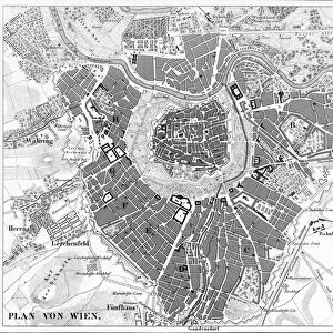
Map of Vienna

![]()
Wall Art and Photo Gifts from Mary Evans Picture Library
Map of Vienna
Map of Vienna, Austria Date: 19th century
Mary Evans Picture Library makes available wonderful images created for people to enjoy over the centuries
Media ID 7404303
© Mary Evans Picture Library 2015 - https://copyrighthub.org/s0/hub1/creation/maryevans/MaryEvansPictureID/10474583
FEATURES IN THESE COLLECTIONS
> Mary Evans Prints Online
> National Archives
EDITORS COMMENTS
1. Title: "A Journey Through Time: Exploring the 19th Century Map of Vienna, Austria" This antique map print, titled "Map of Vienna and its Environs," offers a fascinating glimpse into the urban landscape of Austria's historic capital city during the 19th century. Dating back to an era when Vienna was at the pinnacle of its cultural and intellectual influence, this map invites us to embark on a journey through time and discover the city's rich history. The map, meticulously crafted in the 19th century, reveals the intricate details of Vienna's urban fabric during this period. The city's grand architecture, including the Schönbrunn Palace, the Hofburg Palace, and St. Stephen's Cathedral, are all clearly marked, providing a visual representation of the opulence and grandeur that defined Vienna during this time. The map also highlights the city's extensive green spaces, such as the Prater Park and the Belvedere Gardens, which served as respite from the bustling streets and provided a connection to nature for Vienna's residents. Additionally, the map reveals the city's transportation network, with a focus on the Danube Canal and the extensive network of horse-drawn tram lines that crisscrossed the city. As we explore the intricacies of this map, we are transported back in time to an era when Vienna was a cultural and intellectual powerhouse, a city that inspired the works of Mozart, Beethoven, Freud, and Klimt. This map serves as a testament to the enduring allure of Vienna, a city that continues to captivate and inspire visitors from around the world. The map's intricate details and historical significance make it an invaluable resource for historians, urban planners, and anyone with an interest in the history of Vienna and Austria. This map print is a must-have for any collection of historical maps or for those who appreciate the beauty and history of Vienna.
MADE IN THE USA
Safe Shipping with 30 Day Money Back Guarantee
FREE PERSONALISATION*
We are proud to offer a range of customisation features including Personalised Captions, Color Filters and Picture Zoom Tools
SECURE PAYMENTS
We happily accept a wide range of payment options so you can pay for the things you need in the way that is most convenient for you
* Options may vary by product and licensing agreement. Zoomed Pictures can be adjusted in the Cart.