Home > Europe > Spain > Maps
Map of Madrid (1762) by Ventura Rodrez and
 by Ventura Rodrez and")
![]()
Wall Art and Photo Gifts from Mary Evans Picture Library
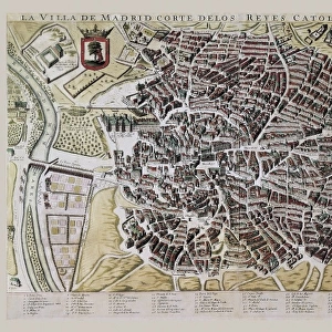
Map of Madrid (1762) by Ventura Rodrez and
" Map of Madrid (1762) by Ventura Rodr ez and published in " La guic de forasteros" (1765). Engraving. SPAIN. Madrid. Museo de Historia."
Mary Evans Picture Library makes available wonderful images created for people to enjoy over the centuries
Media ID 8278687
© Mary Evans Picture Library 2015 - https://copyrighthub.org/s0/hub1/creation/maryevans/MaryEvansPictureID/10684596
Cartography Engravings Historia Museo Pole Poles Rodrez Rodriguez Rods Stick Sticks Ventura
FEATURES IN THESE COLLECTIONS
> Maps and Charts
> Spain
EDITORS COMMENTS
This print showcases an intricately detailed map of Madrid, Spain, created by the renowned cartographer Ventura Rodrez in 1762. The map, titled "Mapa de Madrid," was originally published in the comprehensive guidebook "La guía de forasteros" (The Guide for Foreigners) in 1765. The map's horizontal orientation and rich color palette make it an engaging visual representation of the city's layout during the late Baroque period. The map is an engraving, a technique that involved carving designs into a metal plate, which was then inked and pressed onto paper to create a print. The intricate details of the map, such as the winding streets, city walls, and various landmarks, are a testament to the skill and artistry of the engraver. The map is housed in the prestigious Museo de Historia in Madrid, Spain, where it is preserved and admired by scholars and visitors alike. The map's historical significance lies in its accurate representation of Madrid during a time of great cultural and artistic flourishing. The map is adorned with various symbols and labels, including sticks and rods to denote different types of land use, such as vineyards and gardens. These details provide valuable insights into the city's agricultural and economic activities during the 18th century. The map's title, "Mapa de Madrid," is inscribed at the top, while the cartouche, a decorative border, features an image of a city gate and various allegorical figures representing the virtues of Madrid. The map's intricate details and historical significance make it a fascinating window into the past and a valuable addition to any collection of historical cartography.
MADE IN THE USA
Safe Shipping with 30 Day Money Back Guarantee
FREE PERSONALISATION*
We are proud to offer a range of customisation features including Personalised Captions, Color Filters and Picture Zoom Tools
SECURE PAYMENTS
We happily accept a wide range of payment options so you can pay for the things you need in the way that is most convenient for you
* Options may vary by product and licensing agreement. Zoomed Pictures can be adjusted in the Cart.