Home > Europe > Germany > Maps
Map / Europe / Germany 1789

![]()
Wall Art and Photo Gifts from Mary Evans Picture Library
Map / Europe / Germany 1789
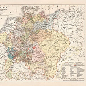
Map of Germany in the late 18th century, showing the many independent states Date: 1789
Mary Evans Picture Library makes available wonderful images created for people to enjoy over the centuries
Media ID 8192915
© Mary Evans Picture Library 2015 - https://copyrighthub.org/s0/hub1/creation/maryevans/MaryEvansPictureID/10114036
FEATURES IN THESE COLLECTIONS
EDITORS COMMENTS
1. Title: Map of Germany in the Late 18th Century: A Snapshot of Independent States Before the French Revolution This map print, dated 1789, offers a fascinating glimpse into the political landscape of Europe, specifically focusing on the intricate mosaic of independent states that made up Germany during the late 18th century. The map, which is not to be confused with any specific map-publishing company, is an essential historical document that provides valuable context to the complex political situation in Europe on the brink of the French Revolution. The map's intricate details reveal a Germany that was a patchwork of numerous principalities, duchies, and free cities, each with its distinct borders and territories. The map's title, "Carte de l'Allemagne," further emphasizes the geographical focus on the German-speaking region. The year 1789 is significant, as it marks the eve of the French Revolution, which would drastically alter the political landscape of Europe and ultimately impact the independent states of Germany in profound ways. The map's meticulous depiction of the various territories and their borders underscores the complexity of the political situation in Germany during this period. The map's vibrant colors and clear labeling make it an engaging and informative visual representation of a time when the European political landscape was vastly different from what it is today. This map print is an invaluable resource for historians, educators, and anyone with an interest in European history, providing a unique perspective on the political situation in Germany during the late 18th century. It serves as a reminder of the rich historical tapestry that lies beneath the modern European Union and invites us to explore the complex web of political relationships that once defined the European continent.
MADE IN THE USA
Safe Shipping with 30 Day Money Back Guarantee
FREE PERSONALISATION*
We are proud to offer a range of customisation features including Personalised Captions, Color Filters and Picture Zoom Tools
SECURE PAYMENTS
We happily accept a wide range of payment options so you can pay for the things you need in the way that is most convenient for you
* Options may vary by product and licensing agreement. Zoomed Pictures can be adjusted in the Cart.