Home > North America > Jamaica > Maps
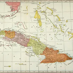
Mouse Mat : Map / West Indies 1683

![]()
Home Decor from Mary Evans Picture Library
Map / West Indies 1683
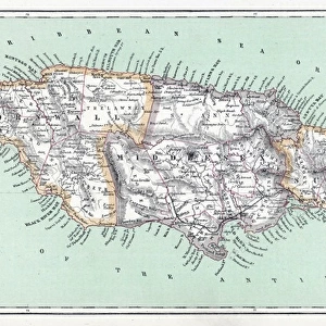
Map of Cuba and Jamaica
Mary Evans Picture Library makes available wonderful images created for people to enjoy over the centuries
Media ID 608842
© Mary Evans Picture Library 2015 - https://copyrighthub.org/s0/hub1/creation/maryevans/MaryEvansPictureID/10114144
Mouse Pad
Standard Size Mouse Pad 7.75" x 9..25". High density Neoprene w linen surface. Easy to clean, stain resistant finish. Rounded corners.
Archive quality photographic print in a durable wipe clean mouse mat with non slip backing. Works with all computer mice
Estimated Image Size (if not cropped) is 16.6cm x 23.7cm (6.5" x 9.3")
Estimated Product Size is 20.2cm x 23.7cm (8" x 9.3")
These are individually made so all sizes are approximate
Artwork printed orientated as per the preview above, with portrait (vertical) orientation to match the source image.
FEATURES IN THESE COLLECTIONS
> Maps and Charts
> Early Maps
> North America
> Cuba
> Maps
> North America
> Cuba
> Related Images
> North America
> Jamaica
> Maps
> North America
> Jamaica
> Related Images
EDITORS COMMENTS
This stunning vintage map print from Mary Evans Picture Library takes us back to the year 1683, providing a fascinating glimpse into the history of the West Indies. The intricate details and ornate design of this map of Cuba and Jamaica showcase the artistry and precision that went into cartography during this time period.
The rich historical significance of this map is evident in every line and symbol, offering a window into the past when these islands were vital hubs for trade, exploration, and colonization. From the lush landscapes to the coastal waters teeming with ships, every element on this map tells a story of adventure and discovery.
As we study this piece closely, we can imagine sailors navigating their way through treacherous waters, settlers establishing new communities, and indigenous peoples living harmoniously with nature. It serves as a reminder of how interconnected our world has always been, even centuries ago.
Whether you have a personal connection to these lands or simply appreciate fine craftsmanship, this Map / West Indies 1683 print is sure to spark your curiosity and ignite your imagination. Display it proudly in your home or office as a conversation piece that will transport you back in time every time you gaze upon it.
MADE IN THE USA
Safe Shipping with 30 Day Money Back Guarantee
FREE PERSONALISATION*
We are proud to offer a range of customisation features including Personalised Captions, Color Filters and Picture Zoom Tools
SECURE PAYMENTS
We happily accept a wide range of payment options so you can pay for the things you need in the way that is most convenient for you
* Options may vary by product and licensing agreement. Zoomed Pictures can be adjusted in the Cart.