Home > Asia > Nepal > Maps
MAPS / INDIA 1908

![]()
Wall Art and Photo Gifts from Mary Evans Picture Library
MAPS / INDIA 1908
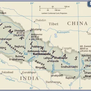
Map of India Date: 1908
Mary Evans Picture Library makes available wonderful images created for people to enjoy over the centuries
Media ID 7151109
© Mary Evans Picture Library 2015 - https://copyrighthub.org/s0/hub1/creation/maryevans/MaryEvansPictureID/10149945
Arabian Bengal Himalayas Maps Nepal
FEATURES IN THESE COLLECTIONS
> Maps and Charts
> India
EDITORS COMMENTS
This antique map print, titled "India," dates back to 1908, offering a fascinating glimpse into the geographical understanding of Asia during that era. The map meticulously depicts the Indian subcontinent, with its intricate details revealing the political divisions and geographical features of the region at the time. The Arabian Sea borders the western coast of India, while the Bay of Bengal lies to the east. Nepal, nestled in the Himalayas, is clearly marked, showcasing its unique position sandwiched between India and China. The vast expanse of the Himalayas, home to some of the world's highest peaks, dominates the northern border of India, adding to the map's grandeur. The map also highlights various provinces, princely states, and British territories, reflecting the colonial influence that was prevalent during this period. The intricate detailing of the map extends to the depiction of rivers, mountains, and other topographical features, making it an essential historical document for scholars, researchers, and anyone interested in the rich history of India and its neighboring countries. This map print, with its intricate details and captivating design, serves as a testament to the cartographic advancements of the late 19th and early 20th centuries. It provides a unique perspective into the geographical knowledge of the time and is an invaluable addition to any collection focused on Asian history, cartography, or geography.
MADE IN THE USA
Safe Shipping with 30 Day Money Back Guarantee
FREE PERSONALISATION*
We are proud to offer a range of customisation features including Personalised Captions, Color Filters and Picture Zoom Tools
FREE COLORIZATION SERVICE
You can choose advanced AI Colorization for this picture at no extra charge!
SECURE PAYMENTS
We happily accept a wide range of payment options so you can pay for the things you need in the way that is most convenient for you
* Options may vary by product and licensing agreement. Zoomed Pictures can be adjusted in the Cart.