Home > Arts > Artists > T > John Tallis
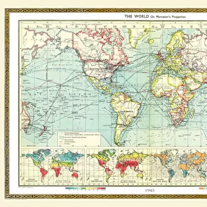
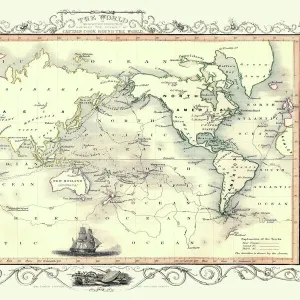
Old Map of the World on Mercators Projection 1851 Showing the Voyages of Captain Cook by John Tallis

![]()
Wall Art and Photo Gifts from MapSeeker
Old Map of the World on Mercators Projection 1851 Showing the Voyages of Captain Cook by John Tallis
A fine facimile artworked from an antique original map of The World on Mercators Projection Showing the Voyages of Capatain Cook, issued as part of the 1851 edition of John Tallis and Companys " The Illustrated Atlas and Modern History of the World"
Welcome to the Mapseeker Image library and enter an historic gateway to one of the largest on-line collections of Historic Maps, Nostalgic Views, Vista's and Panorama's from a World gone by.
Media ID 20347475
© Mapseeker Publishing Ltd
Map Of The World Old Map Of The World The World World Map Captain Cook
FEATURES IN THESE COLLECTIONS
> Arts
> Artists
> T
> John Tallis
> Maps and Charts
> Related Images
> Maps and Charts
> World
> MapSeeker
> Maps Showing the World
> Maps of The World on Mercators
EDITORS COMMENTS
This print showcases an exquisite piece of cartographic history - the "Old Map of the World on Mercators Projection 1851 Showing the Voyages of Captain Cook" by John Tallis. Crafted with utmost precision and attention to detail, this fine facsimile artwork faithfully replicates an antique original map from the renowned 1851 edition of John Tallis and Company's "The Illustrated Atlas and Modern History of the World". Transporting us back in time, this mesmerizing map offers a glimpse into the world as it was during Captain Cook's voyages. The Mercator's projection employed here allows for accurate representation of landmasses while highlighting Cook's remarkable journeys across vast oceans. Every inch of this meticulously crafted map is adorned with intricate illustrations, depicting exotic lands, mythical sea creatures, and celestial bodies that once ignited curiosity and sparked imaginations. It serves as a testament to both scientific knowledge and artistic prowess prevalent during that era. As we gaze upon this extraordinary creation, we are reminded not only of Captain Cook's intrepid spirit but also how maps have shaped our understanding of the world throughout history. This stunning print is a treasure trove for collectors, historians, or anyone fascinated by exploration and discovery. Its timeless beauty invites us to embark on our own voyage through time as we explore distant shores captured within its borders.
MADE IN THE USA
Safe Shipping with 30 Day Money Back Guarantee
FREE PERSONALISATION*
We are proud to offer a range of customisation features including Personalised Captions, Color Filters and Picture Zoom Tools
SECURE PAYMENTS
We happily accept a wide range of payment options so you can pay for the things you need in the way that is most convenient for you
* Options may vary by product and licensing agreement. Zoomed Pictures can be adjusted in the Cart.