Home > Asia > Thailand > Maps
Jigsaw Puzzle : MAPS / ASIA 1908


![]()
Jigsaw Puzzles from Mary Evans Picture Library
MAPS / ASIA 1908
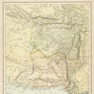
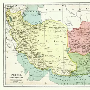
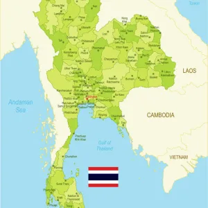
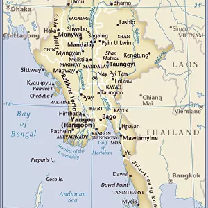
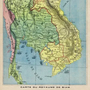
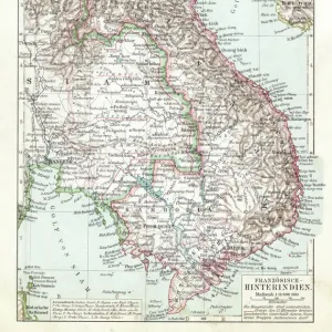
Map of the countries surrounding India Date: 1908
Mary Evans Picture Library makes available wonderful images created for people to enjoy over the centuries
Media ID 7154129
© Mary Evans Picture Library 2015 - https://copyrighthub.org/s0/hub1/creation/maryevans/MaryEvansPictureID/10149941
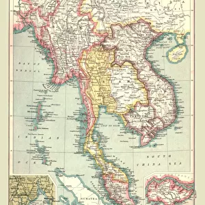
Afghanistan Burma Countries Maps Siam Surrounding Tibet Turkestan
Jigsaw Puzzle (252 Pieces)
Discover the rich history and geography of Asia with our captivating jigsaw puzzle from Media Storehouse. Featuring the intricately detailed map of the Asian continent as it appeared in 1908, this puzzle is a must-have for history buffs and puzzle enthusiasts alike. With a stunning image sourced from Mary Evans Prints Online, this puzzle offers a challenging and rewarding experience for all ages. Journey through the diverse landscapes and borders of Asia as you piece together this beautiful puzzle, transporting you to a time when exploration and discovery were at the forefront of human curiosity.
Made in the USA, 252-piece puzzles measure 11" x 14" (27.9 x 35.5 cm). Every puzzle is meticulously printed on glossy photo paper, which has a strong 1.33 mm thickness. Delivered in a black storage cardboard box, these puzzles are both stylish and practical. (Note: puzzles contain small parts and are not suitable for children under 3 years of age.)
Jigsaw Puzzles are an ideal gift for any occasion
Estimated Product Size is 28cm x 35.6cm (11" x 14")
These are individually made so all sizes are approximate
Artwork printed orientated as per the preview above, with portrait (vertical) orientation to match the source image.
FEATURES IN THESE COLLECTIONS
> Asia
> Afghanistan
> Maps
> Asia
> Afghanistan
> Related Images
> Asia
> Myanmar
> Related Images
> Asia
> Thailand
> Related Images
> Asia
> Turkmenistan
> Maps
> Maps and Charts
> India
EDITORS COMMENTS
This vintage map print, hailing from the year 1908, showcases the intricate geography of Asia, with a particular focus on the countries surrounding India. The map, titled "Map of the Countries Surrounding India," offers a glimpse into the political landscape of the region during that era. Prominently featured are India, Tibet, and Burma, which were significant territories at the time. Afghanistan, Siam (now Thailand), and Turkestan are also clearly marked, providing context to the broader geographical expanse. The map's intricate detailing reveals the borders and names of various provinces, cities, and rivers, offering a fascinating look into the historical cartography of the region. The use of bold colors and clear labeling makes for an engaging and informative visual representation of the area. The map serves as a testament to the rich history and cultural diversity of Asia, as well as the exploration and discovery that characterized the early 20th century. It is a reminder of the intricate interconnections between the various countries and territories, and the complex political landscape that existed during that time. This map print is an essential addition to any collection of historical maps or for those with an interest in Asian history, geography, or cartography. Its vintage charm and educational value make it a captivating conversation starter and a beautiful decorative piece.
MADE IN THE USA
Safe Shipping with 30 Day Money Back Guarantee
FREE PERSONALISATION*
We are proud to offer a range of customisation features including Personalised Captions, Color Filters and Picture Zoom Tools
FREE COLORIZATION SERVICE
You can choose advanced AI Colorization for this picture at no extra charge!
SECURE PAYMENTS
We happily accept a wide range of payment options so you can pay for the things you need in the way that is most convenient for you
* Options may vary by product and licensing agreement. Zoomed Pictures can be adjusted in the Cart.