Home > Asia > Japan > Maps
Photographic Print : Maps / Americas 1540


![]()
Photo Prints from Mary Evans Picture Library
Maps / Americas 1540
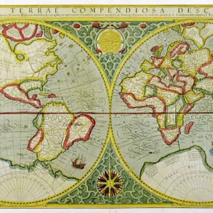
Map showing the discoveries by explorers during the first half-century after Columbus : note the confusion of India, Japan (Zipangri) and China (Cathay), & the Hesperides
Mary Evans Picture Library makes available wonderful images created for people to enjoy over the centuries
Media ID 582445
© Mary Evans Picture Library 2015 - https://copyrighthub.org/s0/hub1/creation/maryevans/MaryEvansPictureID/10029704
1540 Cathay Columbus Confusion Discoveries Explorers Half Hesperides Maps Note
14"x11" Photo Print
Discover the fascinating history of early explorations with our "Maps / Americas 1540" print from the Media Storehouse range of Photographic Prints, brought to you by Mary Evans Picture Library. This exquisite map, dating back to the year 1540, showcases the discoveries made during the first half-century after Columbus's groundbreaking voyage. With intricate detail, the map illustrates the expanding knowledge of the New World, including the misconceptions of India, Japan (Zipangri), and China (Cathay). Delve into the rich history of exploration and cartography with this captivating piece, perfect for any history or geography enthusiast's collection. Order your print today from Media Storehouse and bring a piece of historical significance into your home or office.
Photo prints are produced on Kodak professional photo paper resulting in timeless and breath-taking prints which are also ideal for framing. The colors produced are rich and vivid, with accurate blacks and pristine whites, resulting in prints that are truly timeless and magnificent. Whether you're looking to display your prints in your home, office, or gallery, our range of photographic prints are sure to impress. Dimensions refers to the size of the paper in inches.
Our Photo Prints are in a large range of sizes and are printed on Archival Quality Paper for excellent colour reproduction and longevity. They are ideal for framing (our Framed Prints use these) at a reasonable cost. Alternatives include cheaper Poster Prints and higher quality Fine Art Paper, the choice of which is largely dependant on your budget.
Estimated Product Size is 35.5cm x 27.9cm (14" x 11")
These are individually made so all sizes are approximate
Artwork printed orientated as per the preview above, with landscape (horizontal) or portrait (vertical) orientation to match the source image.
FEATURES IN THESE COLLECTIONS
> Asia
> India
> Related Images
> Asia
> Japan
> Related Images
> Maps and Charts
> Early Maps
> Maps and Charts
> India
> Mary Evans Prints Online
> Maps
EDITORS COMMENTS
This fascinating print from Mary Evans Picture Library showcases a map of the Americas from 1540, highlighting the discoveries made by explorers in the first half-century after Columbus. The map is not only historically significant but also visually captivating, with intricate details that reveal the confusion and misconceptions of the time.
One notable aspect of this map is the mix-up of various countries and regions - India, Japan (referred to as Zipangri), and China (known as Cathay) are all depicted in close proximity, showcasing how limited geographical knowledge was during this period. The inclusion of Hesperides adds an element of mystery and intrigue to the map, hinting at mythical lands or unexplored territories.
Overall, this print offers a glimpse into the past and serves as a reminder of how far we have come in terms of cartography and exploration. It is a testament to the bravery and curiosity of early explorers who ventured into unknown waters in search of new lands and opportunities.
Whether you are a history buff or simply appreciate beautiful artwork, this print is sure to spark your imagination and transport you back in time to an era where maps were filled with wonder and possibility.
MADE IN THE USA
Safe Shipping with 30 Day Money Back Guarantee
FREE PERSONALISATION*
We are proud to offer a range of customisation features including Personalised Captions, Color Filters and Picture Zoom Tools
SECURE PAYMENTS
We happily accept a wide range of payment options so you can pay for the things you need in the way that is most convenient for you
* Options may vary by product and licensing agreement. Zoomed Pictures can be adjusted in the Cart.