Home > Europe > Germany > Maps
Jigsaw Puzzle : Map / Europe / Germany 18C


![]()
Jigsaw Puzzles from Mary Evans Picture Library
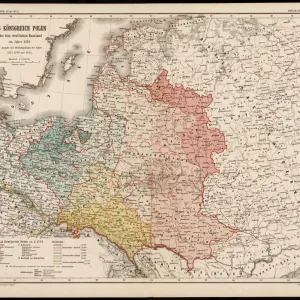
Map / Europe / Germany 18C
Showing the end of the old German Empire and the reconstruction of the German States, 1791 - 1815
Mary Evans Picture Library makes available wonderful images created for people to enjoy over the centuries
Media ID 4335685
© Mary Evans Picture Library 2015 - https://copyrighthub.org/s0/hub1/creation/maryevans/MaryEvansPictureID/10064864
Jigsaw Puzzle (252 Pieces)
Discover the rich history of Europe with our intriguing jigsaw puzzle from Media Storehouse - "Map / Europe / Germany 18C" by Rights Managed from Mary Evans Prints Online. This captivating puzzle transports you back in time, depicting the end of the Old German Empire and the reconstruction of the German States between 1791 and 1815. With intricate details and vibrant colors, this puzzle is an excellent way to engage your mind and learn about history in a fun and interactive way. Challenge yourself and your family to piece together this fascinating puzzle, perfect for history enthusiasts and puzzle lovers alike.
Made in the USA, 252-piece puzzles measure 11" x 14" (27.9 x 35.5 cm). Every puzzle is meticulously printed on glossy photo paper, which has a strong 1.33 mm thickness. Delivered in a black storage cardboard box, these puzzles are both stylish and practical. (Note: puzzles contain small parts and are not suitable for children under 3 years of age.)
Jigsaw Puzzles are an ideal gift for any occasion
Estimated Product Size is 35.6cm x 28cm (14" x 11")
These are individually made so all sizes are approximate
Artwork printed orientated as per the preview above, with landscape (horizontal) orientation to match the source image.
FEATURES IN THESE COLLECTIONS
> Maps and Charts
> Early Maps
EDITORS COMMENTS
This print showcases a historical map of Europe, specifically Germany in the 18th century. The map provides a fascinating glimpse into the end of the old German Empire and the subsequent reconstruction of the German states between 1791 and 1815.
The intricate details on this map highlight the complex political landscape of that time period, with borders shifting and territories being reorganized. It serves as a valuable visual representation of a pivotal moment in European history when power dynamics were evolving and new alliances were forming.
As we study this map, we can't help but be drawn into the story it tells about Germany's journey towards modernization and unity. The meticulous craftsmanship evident in every line and label is a testament to the cartographer's skill and dedication to accuracy.
For history buffs and enthusiasts alike, this print is sure to spark curiosity and inspire further exploration into the events that shaped Germany during this transformative era. It serves as both an educational tool and a work of art, offering viewers a window into the past like never before.
MADE IN THE USA
Safe Shipping with 30 Day Money Back Guarantee
FREE PERSONALISATION*
We are proud to offer a range of customisation features including Personalised Captions, Color Filters and Picture Zoom Tools
SECURE PAYMENTS
We happily accept a wide range of payment options so you can pay for the things you need in the way that is most convenient for you
* Options may vary by product and licensing agreement. Zoomed Pictures can be adjusted in the Cart.