Home > Europe > Germany > Maps
Framed Print : Map / Europe / Germany 18C


![]()
Framed Photos from Mary Evans Picture Library
Map / Europe / Germany 18C
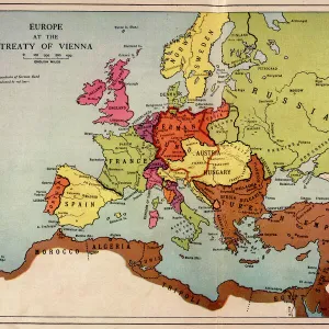
Showing the end of the old German Empire and the reconstruction of the German States, 1791 - 1815
Mary Evans Picture Library makes available wonderful images created for people to enjoy over the centuries
Media ID 4335685
© Mary Evans Picture Library 2015 - https://copyrighthub.org/s0/hub1/creation/maryevans/MaryEvansPictureID/10064864
22"x18" Modern Frame
Introducing the captivating "Map / Europe / Germany 18C" from Media Storehouse's Framed Prints collection. This exquisite piece, sourced from Mary Evans Prints Online, offers a fascinating glimpse into European history. The map illustrates the complex political landscape of Germany during a pivotal period, marking the end of the Old German Empire and the reconstruction of German States from 1791 to 1815. Add this intriguing historical artifact to your home or office decor and embark on a journey through time. With our high-quality framing, you'll not only own an impressive piece of history but also a beautifully presented work of art.
20x16 Print in an MDF Wooden Frame with 180 gsm Satin Finish Paper. Glazed using shatter proof thin plexiglass. Frame thickness is 1 inch and depth 0.75 inch. Fluted cardboard backing held with clips. Supplied ready to hang with sawtooth hanger and rubber bumpers. Spot clean with a damp cloth. Packaged foam wrapped in a card.
Contemporary Framed and Mounted Prints - Professionally Made and Ready to Hang
Estimated Image Size (if not cropped) is 50.8cm x 45.7cm (20" x 18")
Estimated Product Size is 55.9cm x 45.7cm (22" x 18")
These are individually made so all sizes are approximate
Artwork printed orientated as per the preview above, with landscape (horizontal) orientation to match the source image.
FEATURES IN THESE COLLECTIONS
> Maps and Charts
> Early Maps
EDITORS COMMENTS
This print showcases a historical map of Europe, specifically Germany in the 18th century. The map provides a fascinating glimpse into the end of the old German Empire and the subsequent reconstruction of the German states between 1791 and 1815.
The intricate details on this map highlight the complex political landscape of that time period, with borders shifting and territories being reorganized. It serves as a valuable visual representation of a pivotal moment in European history when power dynamics were evolving and new alliances were forming.
As we study this map, we can't help but be drawn into the story it tells about Germany's journey towards modernization and unity. The meticulous craftsmanship evident in every line and label is a testament to the cartographer's skill and dedication to accuracy.
For history buffs and enthusiasts alike, this print is sure to spark curiosity and inspire further exploration into the events that shaped Germany during this transformative era. It serves as both an educational tool and a work of art, offering viewers a window into the past like never before.
MADE IN THE USA
Safe Shipping with 30 Day Money Back Guarantee
FREE PERSONALISATION*
We are proud to offer a range of customisation features including Personalised Captions, Color Filters and Picture Zoom Tools
SECURE PAYMENTS
We happily accept a wide range of payment options so you can pay for the things you need in the way that is most convenient for you
* Options may vary by product and licensing agreement. Zoomed Pictures can be adjusted in the Cart.