Home > Europe > Germany > Maps
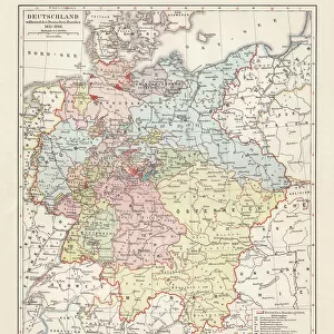
Photographic Print : Map / Europe / Germany 1866


![]()
Photo Prints from Mary Evans Picture Library
Map / Europe / Germany 1866
The growth of Prussia between 1815 and 1866
Mary Evans Picture Library makes available wonderful images created for people to enjoy over the centuries
Media ID 4379495
© Mary Evans Picture Library 2015 - https://copyrighthub.org/s0/hub1/creation/maryevans/MaryEvansPictureID/10071954
14"x11" Photo Print
Step back in time with our exquisite print from the Media Storehouse collection, featuring the map "Europe / Germany 1866" by Rights Managed from Mary Evans Prints Online. This captivating image illustrates the significant growth of Prussia between 1815 and 1866. A must-have for history enthusiasts, educators, or anyone with an appreciation for the evolution of European borders, this print is not only a beautiful addition to your home or office décor but also a fascinating glimpse into the past. Order yours today and let history come alive!
Photo prints are produced on Kodak professional photo paper resulting in timeless and breath-taking prints which are also ideal for framing. The colors produced are rich and vivid, with accurate blacks and pristine whites, resulting in prints that are truly timeless and magnificent. Whether you're looking to display your prints in your home, office, or gallery, our range of photographic prints are sure to impress. Dimensions refers to the size of the paper in inches.
Our Photo Prints are in a large range of sizes and are printed on Archival Quality Paper for excellent colour reproduction and longevity. They are ideal for framing (our Framed Prints use these) at a reasonable cost. Alternatives include cheaper Poster Prints and higher quality Fine Art Paper, the choice of which is largely dependant on your budget.
Estimated Image Size (if not cropped) is 21.3cm x 35.5cm (8.4" x 14")
Estimated Product Size is 27.9cm x 35.5cm (11" x 14")
These are individually made so all sizes are approximate
Artwork printed orientated as per the preview above, with portrait (vertical) orientation to match the source image.
FEATURES IN THESE COLLECTIONS
> Maps and Charts
> Early Maps
EDITORS COMMENTS
This print of a historical map showcases the growth of Prussia between 1815 and 1866, offering a fascinating glimpse into Europe's past. The intricate details on the map highlight Germany's evolution during this period, with Prussia emerging as a dominant force in the region.
The borders and territories depicted on the map provide valuable insights into how political landscapes shifted over time, shaping the history of Europe. From small changes to significant expansions, each line and boundary tells a story of conquests, alliances, and power struggles that defined this era.
As we study this meticulously crafted representation of Germany in 1866, we can't help but marvel at the precision and artistry that went into creating such an informative piece. Every city, river, and mountain range is carefully labeled and illustrated to give us a comprehensive understanding of the geography and politics of the time.
Whether you're a history buff or simply intrigued by maps, this print offers endless opportunities for exploration and discovery. It serves as a reminder of how much our world has changed over centuries while also highlighting enduring legacies that continue to shape our present-day realities. Dive into this visual treasure trove and let your imagination roam through the corridors of European history.
MADE IN THE USA
Safe Shipping with 30 Day Money Back Guarantee
FREE PERSONALISATION*
We are proud to offer a range of customisation features including Personalised Captions, Color Filters and Picture Zoom Tools
SECURE PAYMENTS
We happily accept a wide range of payment options so you can pay for the things you need in the way that is most convenient for you
* Options may vary by product and licensing agreement. Zoomed Pictures can be adjusted in the Cart.