Home > Asia > Iran > Maps
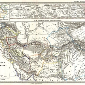
Jigsaw Puzzle : Map / Asia / Persia 19C


![]()
Jigsaw Puzzles from Mary Evans Picture Library
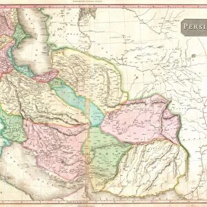
Map / Asia / Persia 19C
Map of Persia (Iran)
Mary Evans Picture Library makes available wonderful images created for people to enjoy over the centuries
Media ID 608860
© Mary Evans Picture Library 2015 - https://copyrighthub.org/s0/hub1/creation/maryevans/MaryEvansPictureID/10114195
Jigsaw Puzzle (252 Pieces)
Discover the captivating world of the Media Storehouse Jigsaw Puzzles with this exquisite representation of "Map / Asia / Persia 19C" from Mary Evans Picture Library. Transport yourself back in time as you piece together this intricate puzzle, featuring a detailed map of Persia (now known as Iran) from the 19th century. With vibrant colors and meticulous detail, this jigsaw puzzle is not just a fun activity, but an educational and visually stunning experience. Immerse yourself in the rich history and culture of Persia as you complete this beautifully designed puzzle. Perfect for puzzle enthusiasts, history buffs, or anyone looking for a challenging and rewarding pastime.
Made in the USA, 252-piece puzzles measure 11" x 14" (27.9 x 35.5 cm). Every puzzle is meticulously printed on glossy photo paper, which has a strong 1.33 mm thickness. Delivered in a black storage cardboard box, these puzzles are both stylish and practical. (Note: puzzles contain small parts and are not suitable for children under 3 years of age.)
Jigsaw Puzzles are an ideal gift for any occasion
Estimated Product Size is 35.6cm x 28cm (14" x 11")
These are individually made so all sizes are approximate
Artwork printed orientated as per the preview above, with landscape (horizontal) orientation to match the source image.
FEATURES IN THESE COLLECTIONS
> Asia
> Iran
> Related Images
> Maps and Charts
> Early Maps
EDITORS COMMENTS
This stunning print of a 19th-century map of Persia (Iran) from the Mary Evans Picture Library is a captivating glimpse into the historical geography of Asia. The intricate details and vibrant colors bring to life the rich history and cultural significance of this region.
As we study this map, we are transported back in time to an era when cartography was both an art form and a scientific endeavor. The careful craftsmanship and attention to detail evident in every line and symbol on this map speak to the skill and dedication of the cartographer who created it.
Persia, with its ancient cities, majestic mountains, and vast deserts, is depicted with precision and beauty on this map. From Tehran to Isfahan, Shiraz to Tabriz, each place name evokes images of a bygone era filled with intrigue and adventure.
Whether you are a history buff, a geography enthusiast, or simply appreciate fine artistry, this print is sure to captivate your imagination. Display it proudly in your home or office as a conversation piece that sparks curiosity about the past.
Let this Map of Persia serve as a reminder of the enduring legacy of one of Asia's most storied civilizations.
MADE IN THE USA
Safe Shipping with 30 Day Money Back Guarantee
FREE PERSONALISATION*
We are proud to offer a range of customisation features including Personalised Captions, Color Filters and Picture Zoom Tools
SECURE PAYMENTS
We happily accept a wide range of payment options so you can pay for the things you need in the way that is most convenient for you
* Options may vary by product and licensing agreement. Zoomed Pictures can be adjusted in the Cart.