Home > Asia > Hong Kong > Maps
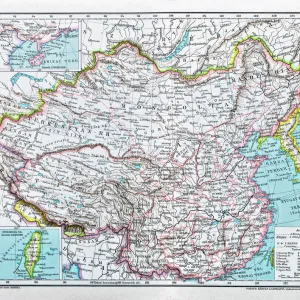
Framed Print : Map / Asia / China 1871


![]()
Framed Photos from Mary Evans Picture Library
Map / Asia / China 1871
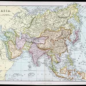
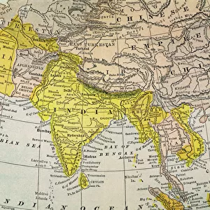
The CHINESE EMPIRE with Korea and Japan. The Treaty Ports are underlined, Hong Kong is underlined in red Date: 1871
Mary Evans Picture Library makes available wonderful images created for people to enjoy over the centuries
Media ID 7110965
© Mary Evans Picture Library 2015 - https://copyrighthub.org/s0/hub1/creation/maryevans/MaryEvansPictureID/10004466
1871 Hong Kong Korea Maps Ports Treaty Underlined
22"x18" Modern Frame
Discover the rich history of Asia with our stunning framed print, "Map / Asia / China 1871" from Media Storehouse. This exquisite piece, sourced from Mary Evans Prints Online, showcases an intricately detailed map of the Chinese Empire during the year 1871. With Korea and Japan depicted, treaty ports are underlined, and Hong Kong highlighted in bold red. Bring a piece of historical cartography into your home or office with this beautifully framed and preserved print, sure to captivate and inspire. #AsiaHistory #VintageMaps #China
20x16 Print in an MDF Wooden Frame with 180 gsm Satin Finish Paper. Glazed using shatter proof thin plexiglass. Frame thickness is 1 inch and depth 0.75 inch. Fluted cardboard backing held with clips. Supplied ready to hang with sawtooth hanger and rubber bumpers. Spot clean with a damp cloth. Packaged foam wrapped in a card.
Contemporary Framed and Mounted Prints - Professionally Made and Ready to Hang
Estimated Image Size (if not cropped) is 50.8cm x 45.7cm (20" x 18")
Estimated Product Size is 55.9cm x 45.7cm (22" x 18")
These are individually made so all sizes are approximate
Artwork printed orientated as per the preview above, with landscape (horizontal) orientation to match the source image.
FEATURES IN THESE COLLECTIONS
> Asia
> Hong Kong
> Related Images
EDITORS COMMENTS
This map print, dated 1871, offers a fascinating glimpse into the political landscape of Asia during the Chinese Empire's era of treaty ports. The map meticulously outlines the borders of China, Korea, and Japan, with key treaty ports underlined for emphasis. The Chinese Empire, once a powerful and unified political entity, was being gradually influenced by external forces, leading to the establishment of treaty ports as points of interaction between China and the Western world. The map's vibrant colors and intricate detailing bring to life the geographical features and political divisions of the region. The underlined treaty ports, including Hong Kong, indicate the growing presence of foreign powers in China's territories. Hong Kong, marked in bold red, was a British colony since 1841, and its strategic location made it a crucial trading hub between China and the West. Japan and Korea, situated to the east of China, are also depicted on the map. Japan had already begun its modernization process, while Korea remained largely isolated from the outside world. The map serves as a testament to the complex political dynamics of Asia during the late 19th century, a time of significant change and transformation. This map print, with its historical significance and captivating visual appeal, is an essential addition to any collection focused on Asian history, cartography, or geography. Its intricate detailing and underlined treaty ports offer valuable insights into the political landscape of Asia during the Chinese Empire's era of treaty ports, making it an invaluable resource for scholars, historians, and enthusiasts alike.
MADE IN THE USA
Safe Shipping with 30 Day Money Back Guarantee
FREE PERSONALISATION*
We are proud to offer a range of customisation features including Personalised Captions, Color Filters and Picture Zoom Tools
SECURE PAYMENTS
We happily accept a wide range of payment options so you can pay for the things you need in the way that is most convenient for you
* Options may vary by product and licensing agreement. Zoomed Pictures can be adjusted in the Cart.