Home > Europe > United Kingdom > England > London > Politics > Frederick North
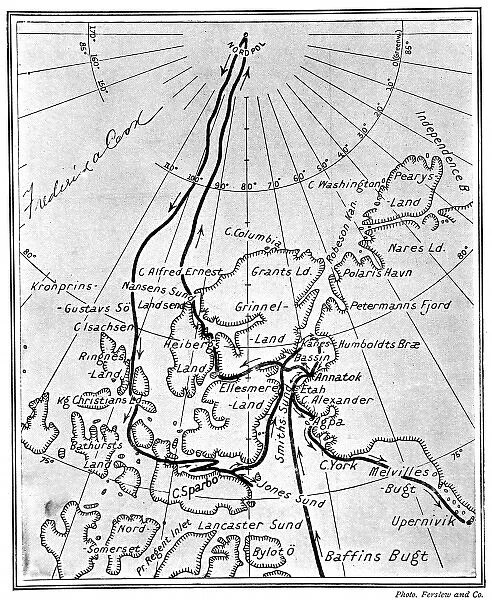
Canvas Print : Map showing Dr. Frederick Cooks route to the North Pole, 19
![]()

Canvas Prints from Mary Evans Picture Library
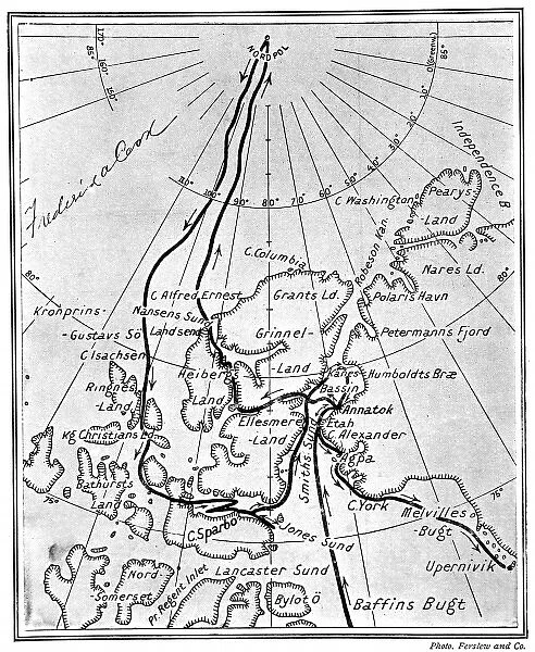
Map showing Dr. Frederick Cooks route to the North Pole, 19
Map showing the route taken by Dr. Frederick A. Cook and his Inuit companions, Ah-welsh and Etukishook, to the North Pole, in 1907 - 1908. The chart has been signed by the doctor, at top left. A debate has long raged over whether it was Cook or Peary who first reached the North Pole, but it seems that Dr. Cook had a good claim to be first
Mary Evans Picture Library makes available wonderful images created for people to enjoy over the centuries
Media ID 4385835
© Mary Evans Picture Library 2015 - https://copyrighthub.org/s0/hub1/creation/maryevans/MaryEvansPictureID/10217754
Chart Claim Companions Cook Debate Doctor Frederick Good Inuit Peary Pole Reached Route Signed 1907
20"x16" (51x41cm) Canvas Print
Discover the intrigue of polar exploration with our stunning Canvas Print of Dr. Frederick Cook's North Pole Expedition Map. This captivating piece, sourced from Mary Evans Prints Online and available through Media Storehouse, showcases the signed chart detailing Dr. Cook's historic journey to the North Pole with his Inuit companions, Ah-welsh and Etukishook, in 1907-1908. Add an air of adventure to your home or office with this beautifully detailed and authentic reproduction, sure to inspire awe and curiosity. Bring the past to life with our high-quality Canvas Prints.
Delivered stretched and ready to hang our premium quality canvas prints are made from a polyester/cotton blend canvas and stretched over a 1.25" (32mm) kiln dried knot free wood stretcher bar. Packaged in a plastic bag and secured to a cardboard insert for safe transit.
Canvas Prints add colour, depth and texture to any space. Professionally Stretched Canvas over a hidden Wooden Box Frame and Ready to Hang
Estimated Product Size is 40.6cm x 50.8cm (16" x 20")
These are individually made so all sizes are approximate
Artwork printed orientated as per the preview above, with portrait (vertical) orientation to match the source image.
FEATURES IN THESE COLLECTIONS
> Europe
> United Kingdom
> England
> London
> Politics
> Frederick North
> Maps and Charts
> Early Maps
EDITORS COMMENTS
This historic map depicts the route taken by Dr. Frederick A. Cook and his Inuit companions, Ah-welsh and Etukishook, during their groundbreaking expedition to the North Pole in 1907-1908. The chart, signed by Dr. Cook at the top left corner, provides an intriguing glimpse into one of the most hotly debated chapters in polar exploration history. For decades, a contentious debate has raged over who was the first person to reach the North Pole: Dr. Cook or Robert E. Peary. Cook's claim to fame rests on this expedition, during which he and his Inuit companions traversed over 300 miles of treacherous Arctic terrain, braving subzero temperatures and treacherous ice floes. Cook's party reached a position 8°30' N, which they believed placed them at the North Pole. Despite Cook's assertions, Peary's 1909 expedition is generally recognized as the first successful reach of the North Pole. However, recent research and reevaluation of Cook's evidence have led some historians to reconsider his claim. This map, a testament to the determination and courage of Cook and his companions, remains an essential piece of polar exploration history. The map's intricate details, including the names of various landmarks and campsites, offer a fascinating look into the logistics and challenges faced by early polar explorers. The Ilulissat Icefjord, Disko Bay, and Smith Sound are just a few of the notable geographical features marked on the chart. As we continue to explore the vast, uncharted reaches of our planet, this map serves as a reminder of the indomitable human spirit and the relentless pursuit of knowledge and discovery. Signed by Dr. Cook himself, this map is a valuable historical artifact that continues to fuel the imagination and inspire future generations of explorers.
MADE IN THE USA
Safe Shipping with 30 Day Money Back Guarantee
FREE PERSONALISATION*
We are proud to offer a range of customisation features including Personalised Captions, Color Filters and Picture Zoom Tools
FREE COLORIZATION SERVICE
You can choose advanced AI Colorization for this picture at no extra charge!
SECURE PAYMENTS
We happily accept a wide range of payment options so you can pay for the things you need in the way that is most convenient for you
* Options may vary by product and licensing agreement. Zoomed Pictures can be adjusted in the Cart.


