Home > Africa > Ethiopia (Abyssinia) > Maps
Jigsaw Puzzle : Map of the Italian Empire in 1939


![]()
Jigsaw Puzzles from Mary Evans Picture Library
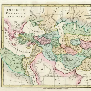
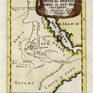
Map of the Italian Empire in 1939
Map of the Italian Empire in 1939, including the colonial African territories of Abyssinia (Ethiopia) and Libya. Date: 1939
Mary Evans Picture Library makes available wonderful images created for people to enjoy over the centuries
Media ID 7212179
© Mary Evans Picture Library 2015 - https://copyrighthub.org/s0/hub1/creation/maryevans/MaryEvansPictureID/10418391
Jigsaw Puzzle (252 Pieces)
Discover the rich history of the Italian Empire with our captivating jigsaw puzzle from Media Storehouse. This intricately detailed puzzle features a vintage map of the Italian Empire in 1939, as obtained from Mary Evans Prints Online. Explore the borders of Italy's colonial territories in Africa, including Abyssinia (Ethiopia) and Libya. Immerse yourself in the past as you piece together this historical puzzle, perfect for history enthusiasts, puzzle collectors, or anyone looking for a challenging and engaging activity. Bring the past to life and create a stunning display piece once completed.
Made in the USA, 252-piece puzzles measure 11" x 14" (27.9 x 35.5 cm). Every puzzle is meticulously printed on glossy photo paper, which has a strong 1.33 mm thickness. Delivered in a black storage cardboard box, these puzzles are both stylish and practical. (Note: puzzles contain small parts and are not suitable for children under 3 years of age.)
Jigsaw Puzzles are an ideal gift for any occasion
Estimated Image Size (if not cropped) is 35.5cm x 25.4cm (14" x 10")
Estimated Product Size is 35.6cm x 28cm (14" x 11")
These are individually made so all sizes are approximate
Artwork printed orientated as per the preview above, with landscape (horizontal) orientation to match the source image.
FEATURES IN THESE COLLECTIONS
> Africa
> Ethiopia (Abyssinia)
> Maps
> Africa
> Ethiopia (Abyssinia)
> Related Images
> Africa
> Ethiopia
> Related Images
> Africa
> Libya
> Related Images
> Maps and Charts
> Italy
EDITORS COMMENTS
This vintage map print depicts the Italian Empire in its entirety as it stood in 1939. The map showcases the extensive territorial reach of the Italian colonial empire, with a particular focus on the African continent. At the heart of the map lies the Italian Peninsula, bordered by the Mediterranean Sea. The empire's African territories, prominently displayed, include the colonies of Libya and Abyssinia (now known as Ethiopia). Italy's conquest of Libya began in 1911, and the region remained under Italian rule until 1943. The map illustrates the vast desert expanses of Libya, as well as its coastal cities and strategic ports. The Italian occupation of Abyssinia, however, was a more contentious affair. The Second Italo-Abyssinian War broke out in 1935, and the Italian forces, led by Benito Mussolini, were able to conquer the country in a relatively short time. The map reveals the mountainous terrain of Abyssinia, with its major rivers and cities. The Italian Empire's reach extended beyond Europe and Africa, with territories in the Balkans, the Mediterranean, and the Horn of Africa. This map serves as a poignant reminder of a time when European powers sought to expand their empires and exert their influence on the global stage. The intricate details and vibrant colors of the map transport us back to a bygone era, offering a fascinating glimpse into the history of Italy and its colonial past.
MADE IN THE USA
Safe Shipping with 30 Day Money Back Guarantee
FREE PERSONALISATION*
We are proud to offer a range of customisation features including Personalised Captions, Color Filters and Picture Zoom Tools
SECURE PAYMENTS
We happily accept a wide range of payment options so you can pay for the things you need in the way that is most convenient for you
* Options may vary by product and licensing agreement. Zoomed Pictures can be adjusted in the Cart.