Home > North America > Greenland > Maps
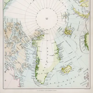
Photographic Print : Map of Smith Sound and Greenland, 1875


![]()
Photo Prints from Mary Evans Picture Library
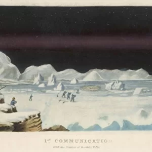
Map of Smith Sound and Greenland, 1875
Engraving showing a map of Smith Sound and Greenland, as it was known in May 1875. Much of the map is erroneous or missing in detail, as the Arctic area had been little visited by Europeans up to that time. In the summer of 1875 the British Admiralty sent Captain George Nares with two ships, HMS Alert and HMS Discovery, to make an attempt to reach the North Pole via Smith Sound. The attempt was unsuccessful, but a new furthest North record was set, the coasts of Greenland and Ellesmere Island were further charted and much scientific data gathered
Mary Evans Picture Library makes available wonderful images created for people to enjoy over the centuries
Media ID 4385033
© Mary Evans Picture Library 2015 - https://copyrighthub.org/s0/hub1/creation/maryevans/MaryEvansPictureID/10217614
1875 Admiralty Arctic Area Attempt Charted Coasts Data Ellesmere Gathered Greenland Missing Nares Pole Reach Record Scientific Sound Unsuccessful Visited Europeans Smith
14"x11" Photo Print
Discover the captivating history of Arctic exploration with our vintage Map of Smith Sound and Greenland, 1875. This stunning engraving, sourced from Mary Evans Prints Online, offers a fascinating glimpse into the cartographic knowledge of the time. Depicting Smith Sound and the expansive Greenland landscape as it was understood in May 1875, this print reveals a wealth of intriguing details and errors that reflect the exploratory spirit of the era. Add an air of antiquated charm to your home or office with this captivating and historically significant piece from the Media Storehouse range of Photographic Prints.
Photo prints are produced on Kodak professional photo paper resulting in timeless and breath-taking prints which are also ideal for framing. The colors produced are rich and vivid, with accurate blacks and pristine whites, resulting in prints that are truly timeless and magnificent. Whether you're looking to display your prints in your home, office, or gallery, our range of photographic prints are sure to impress. Dimensions refers to the size of the paper in inches.
Our Photo Prints are in a large range of sizes and are printed on Archival Quality Paper for excellent colour reproduction and longevity. They are ideal for framing (our Framed Prints use these) at a reasonable cost. Alternatives include cheaper Poster Prints and higher quality Fine Art Paper, the choice of which is largely dependant on your budget.
Estimated Image Size (if not cropped) is 25cm x 35.5cm (9.8" x 14")
Estimated Product Size is 27.9cm x 35.5cm (11" x 14")
These are individually made so all sizes are approximate
Artwork printed orientated as per the preview above, with portrait (vertical) orientation to match the source image.
FEATURES IN THESE COLLECTIONS
> Maps and Charts
> Early Maps
> North America
> Greenland
> Maps
EDITORS COMMENTS
This historical engraving from 1875 shows a map of Smith Sound and Greenland, capturing the limited knowledge Europeans had of the Arctic region at that time. The British Admiralty's attempt to reach the North Pole via Smith Sound with Captain George Nares leading the expedition aboard HMS Alert and HMS Discovery may have been unsuccessful in achieving their ultimate goal, but it did result in setting a new furthest North record.
The map itself is filled with errors and lacks detail due to the lack of European exploration in the area up to that point. However, this mission was not without its successes - further charting of the coasts of Greenland and Ellesmere Island took place, along with valuable scientific data being gathered.
This print serves as an important reminder of the challenges faced by early explorers venturing into uncharted territories, highlighting both their determination and resilience in pushing boundaries. It also stands as a testament to human curiosity and our relentless pursuit of knowledge about our world.
MADE IN THE USA
Safe Shipping with 30 Day Money Back Guarantee
FREE PERSONALISATION*
We are proud to offer a range of customisation features including Personalised Captions, Color Filters and Picture Zoom Tools
SECURE PAYMENTS
We happily accept a wide range of payment options so you can pay for the things you need in the way that is most convenient for you
* Options may vary by product and licensing agreement. Zoomed Pictures can be adjusted in the Cart.