Home > South America > Peru > Maps
Canvas Print : Map of Peru 1683 Mallet


![]()
Canvas Prints from Mary Evans Picture Library
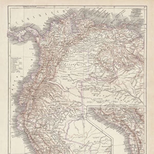
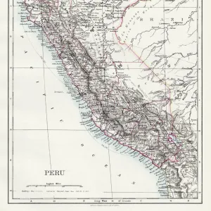
Map of Peru 1683 Mallet
Perou. A map showing a coastal part of South America on the South Pacific. Both the equator and tropic of Capricorn are given
Mary Evans Picture Library makes available wonderful images created for people to enjoy over the centuries
Media ID 589249
© Mary Evans Picture Library 2015 - https://copyrighthub.org/s0/hub1/creation/maryevans/MaryEvansPictureID/10173759
1683 Amazon Capricorn Equator Forest Mallet Maps Pacific Peru Rain Tropic Perou
12"x9" (30x23cm) Canvas Print
Introducing the captivating "Map of Peru 1683 Mallet" from our Media Storehouse Canvas Prints collection, brought to you by Mary Evans Picture Library via Mary Evans Prints Online. This exquisite map, dating back to 1683, showcases a coastal part of South America on the South Pacific. The intricate detailing includes the representation of the equator and the Tropic of Capricorn, making this an essential addition for history enthusiasts and world explorers alike. Our high-quality canvas prints are meticulously crafted to bring the rich history and intrigue of this rare map into your home or office, creating a stunning visual statement. Experience the allure of the past with Media Storehouse Canvas Prints.
Delivered stretched and ready to hang our premium quality canvas prints are made from a polyester/cotton blend canvas and stretched over a 1.25" (32mm) kiln dried knot free wood stretcher bar. Packaged in a plastic bag and secured to a cardboard insert for safe transit.
Canvas Prints add colour, depth and texture to any space. Professionally Stretched Canvas over a hidden Wooden Box Frame and Ready to Hang
Estimated Product Size is 22.9cm x 30.5cm (9" x 12")
These are individually made so all sizes are approximate
Artwork printed orientated as per the preview above, with portrait (vertical) orientation to match the source image.
FEATURES IN THESE COLLECTIONS
> Maps and Charts
> Early Maps
> South America
> Peru
> Maps
> South America
> Peru
> Related Images
EDITORS COMMENTS
This historical map, titled "Perou" and dated 1683, is an intriguing glimpse into the cartographic knowledge of the coastal region of South America during the late 17th century. Produced by the renowned French cartographer Guillaume Sanson and published by Jean Baptiste Nolin, this map is an important representation of the geographical understanding of the area during this time. The map focuses on the coastal part of modern-day Peru, stretching from the northern tip of Ecuador to the southernmost point of Chile. The mapmaker meticulously delineates the rugged coastline, marking various bays, inlets, and capes with great detail. The vast expanse of the Pacific Ocean is depicted to the west, with the equator and the tropic of Capricorn clearly indicated. The Amazon River, the lifeblood of the region, is shown flowing into the Atlantic Ocean, adding to the map's richness and depth. The dense forested areas, teeming with diverse flora and fauna, are depicted with a sense of wonder and curiosity, reflecting the exploratory spirit of the time. The map also includes various place names, some of which are still in use today, such as the cities of Lima, Callao, and Arica. The cartouche at the bottom right corner features an elegant design, complete with a view of a coastal scene, a native American figure, and a European explorer, highlighting the interconnectedness of the Old and New Worlds during this period. This map, created by Guillaume Sanson and published by Jean Baptiste Nolin in 1683, is a valuable historical document that offers a fascinating glimpse into the cartographic knowledge and understanding of the coastal region of South America during the late 17th century. It is a testament to the rich history and diverse geography of the area, and a reminder of the exploratory spirit that drove the cartographic endeavors of the time.
MADE IN THE USA
Safe Shipping with 30 Day Money Back Guarantee
FREE PERSONALISATION*
We are proud to offer a range of customisation features including Personalised Captions, Color Filters and Picture Zoom Tools
SECURE PAYMENTS
We happily accept a wide range of payment options so you can pay for the things you need in the way that is most convenient for you
* Options may vary by product and licensing agreement. Zoomed Pictures can be adjusted in the Cart.