Home > Europe > United Kingdom > England > London > Related Images
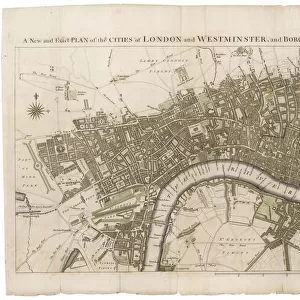
Map of London

![]()
Wall Art and Photo Gifts from Mary Evans Picture Library
Map of London
Mary Evans Picture Library makes available wonderful images created for people to enjoy over the centuries
Media ID 7404449
© Mary Evans Picture Library 2015 - https://copyrighthub.org/s0/hub1/creation/maryevans/MaryEvansPictureID/10474910
FEATURES IN THESE COLLECTIONS
> Europe
> United Kingdom
> England
> London
> Related Images
> Maps and Charts
> Related Images
> Mary Evans Prints Online
> National Archives
EDITORS COMMENTS
1. Title: "Exploring the Labyrinthine Streets of 19th Century London: A Glimpse into the Past with this Detailed Map" Step back in time and embark on a captivating journey through the labyrinthine streets of 19th century London with this intricately detailed map, "Map of London," from the Mary Evans Prints Online archive. This century-old map, dating back to 1852, offers a unique perspective into the urban landscape of London during a time of significant growth and transformation. Measuring 125mm x 170mm, this map is a testament to the meticulous cartography of the era. The map's vibrant colors and clear, bold lines bring the bustling city to life, revealing the intricate network of streets, lanes, and alleys that crisscrossed the heart of London. The map also highlights various points of interest, including the Thames River, major transportation hubs, and notable landmarks such as the Tower of London, St. Paul's Cathedral, and Westminster Abbey. The map's rich historical context is further enhanced by its inclusion of various insets, which provide a closer look at specific areas of the city, such as the City of London, Westminster, and the Southwark district. These insets offer valuable insights into the urban planning and development of these areas during the 19th century. As you explore the intricate details of this map, you'll gain a deeper appreciation for the complex history and evolution of London. This piece is not only a beautiful addition to any home or office, but also a fascinating window into the past that invites endless exploration and discovery. So, take a moment to immerse yourself in the history of London and let this stunning map transport you back in time. Whether you're a history buff, a cartography enthusiast, or simply someone who appreciates the beauty of the past, this Map of London is sure to captivate and inspire you.
MADE IN THE USA
Safe Shipping with 30 Day Money Back Guarantee
FREE PERSONALISATION*
We are proud to offer a range of customisation features including Personalised Captions, Color Filters and Picture Zoom Tools
SECURE PAYMENTS
We happily accept a wide range of payment options so you can pay for the things you need in the way that is most convenient for you
* Options may vary by product and licensing agreement. Zoomed Pictures can be adjusted in the Cart.