Home > Animals > Mammals > Muridae > Desert Mouse
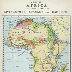
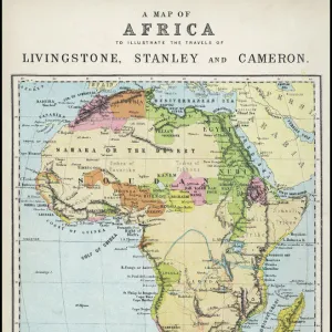
Photographic Print : Map of Africa illustrating travels of explorers


![]()
Photo Prints from Mary Evans Picture Library
Map of Africa illustrating travels of explorers
A map of Africa which illustrates the travels of Livingstone, Stanley and Cameron. Date: 19th Century
Mary Evans Picture Library makes available wonderful images created for people to enjoy over the centuries
Media ID 4307159
© Mary Evans Picture Library 2015 - https://copyrighthub.org/s0/hub1/creation/maryevans/MaryEvansPictureID/10007166
Arabia Cameron Cartography Coding Desert Exploration Explorer Explorers Illustrating Living Stone Madagascar Maps Mediterranean Nubia Persia Sahara Stanley Sudan Travels
14"x11" Photo Print
Discover the rich history of African exploration with our stunning selection of Photographic Prints from Media Storehouse, featuring an intricately detailed Map of Africa from the 19th Century. This captivating image, sourced from Mary Evans Prints Online, highlights the remarkable journeys of renowned explorers David Livingstone, Henry Morton Stanley, and Pierre Savorgnan de Brazza. Bring the spirit of adventure into your home or office and transport yourself back in time with this beautiful and historically significant print. Rights Managed through Mary Evans Prints Online.
Photo prints are produced on Kodak professional photo paper resulting in timeless and breath-taking prints which are also ideal for framing. The colors produced are rich and vivid, with accurate blacks and pristine whites, resulting in prints that are truly timeless and magnificent. Whether you're looking to display your prints in your home, office, or gallery, our range of photographic prints are sure to impress. Dimensions refers to the size of the paper in inches.
Our Photo Prints are in a large range of sizes and are printed on Archival Quality Paper for excellent colour reproduction and longevity. They are ideal for framing (our Framed Prints use these) at a reasonable cost. Alternatives include cheaper Poster Prints and higher quality Fine Art Paper, the choice of which is largely dependant on your budget.
Estimated Image Size (if not cropped) is 26cm x 35.5cm (10.2" x 14")
Estimated Product Size is 27.9cm x 35.5cm (11" x 14")
These are individually made so all sizes are approximate
Artwork printed orientated as per the preview above, with portrait (vertical) orientation to match the source image.
FEATURES IN THESE COLLECTIONS
> Africa
> Egypt
> Related Images
> Africa
> Madagascar
> Maps
> Africa
> Madagascar
> Related Images
> Africa
> Sudan
> Related Images
> Animals
> Mammals
> Muridae
> Desert Mouse
> Maps and Charts
> Early Maps
EDITORS COMMENTS
This print of a Map of Africa from the 19th Century is a historical gem that illustrates the incredible travels of renowned explorers such as Livingstone, Stanley, and Cameron. The map showcases their daring expeditions through vast deserts, across treacherous oceans, and into uncharted territories in Africa.
The intricate details on this Victorian-era map highlight key locations visited by these intrepid explorers, including Egypt, Sudan, Nubia, Madagascar, Persia, and Arabia. Each line drawn represents a journey filled with danger and discovery as they navigated through challenging terrain to uncover new lands and cultures.
The vibrant colors used in this cartographic masterpiece bring to life the spirit of exploration that defined the 19th century. From the Mediterranean Sea to the Sahara Desert, every corner of Africa is meticulously mapped out to showcase the bravery and determination of these trailblazing adventurers.
As you gaze upon this historical artifact from Mary Evans Prints Online, you can't help but be transported back in time to an era when mapping out unknown territories was both a science and an art form. This Map of Africa serves as a testament to human curiosity and resilience in the face of adversity – a true tribute to the indomitable spirit of exploration.
MADE IN THE USA
Safe Shipping with 30 Day Money Back Guarantee
FREE PERSONALISATION*
We are proud to offer a range of customisation features including Personalised Captions, Color Filters and Picture Zoom Tools
SECURE PAYMENTS
We happily accept a wide range of payment options so you can pay for the things you need in the way that is most convenient for you
* Options may vary by product and licensing agreement. Zoomed Pictures can be adjusted in the Cart.