Home > Arts > Landscape paintings > Waterfall and river artworks > River artworks
MAP: NORTH PACIFIC. Nouvelle Carte des ecouvertes faites par des Vaisseaux Russiens

![]()
Wall Art and Photo Gifts from Granger
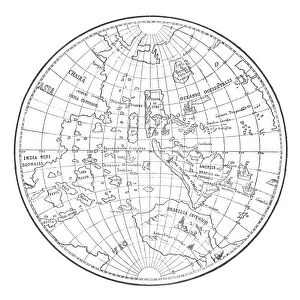
MAP: NORTH PACIFIC. Nouvelle Carte des ecouvertes faites par des Vaisseaux Russiens
MAP: NORTH PACIFIC.
Nouvelle Carte des ecouvertes faites par des Vaisseaux Russiens, showing the voyage of the Great Northern Expedition led by Vitus Bering, 1733-1743. Map by the St. Petersburg Academy, 1758
Granger holds millions of images spanning more than 25,000 years of world history, from before the Stone Age to the dawn of the Space Age
Media ID 12321297
1733 1743 1758 Asia Coast Danish Expedition Exploration Great North America Northern Ocean Pacific Ocean Peninsula Russian Siberia Siberian Vitus Voyage Bering Bering Strait Kamchatka
FEATURES IN THESE COLLECTIONS
> Arts
> Landscape paintings
> Waterfall and river artworks
> River artworks
> Asia
> Related Images
> Granger Art on Demand
> Maps
> North America
> Related Images
EDITORS COMMENTS
This print showcases a historical map titled "MAP: NORTH PACIFIC. Nouvelle Carte des ecouvertes faites par des Vaisseaux Russiens" which translates to "New Map of Discoveries Made by Russian Ships". Created by the St. Petersburg Academy in 1758, this map documents the remarkable voyage of the Great Northern Expedition led by Vitus Bering from 1733 to 1743. The map provides a visual narrative of Bering's expedition, highlighting his exploration and discoveries across the North Pacific region. From the Bering Strait to the coasts of Asia and North America, every detail is meticulously depicted, including rivers, peninsulas, and oceanic boundaries. As we delve into this piece of cartographic history, we are transported back in time to an era when Danish and French explorers joined forces with their Russian counterparts on a quest for knowledge and discovery. The vastness of Siberia unfolds before our eyes as we trace their footsteps through Kamchatka Peninsula and beyond. This print not only serves as a beautiful decorative piece but also offers us a glimpse into an important chapter in human exploration. It reminds us of our innate curiosity about uncharted territories and our relentless pursuit of understanding the world around us. With its rich historical significance and intricate details, this map print from The Granger Collection is sure to captivate both history enthusiasts and art lovers alike.
MADE IN THE USA
Safe Shipping with 30 Day Money Back Guarantee
FREE PERSONALISATION*
We are proud to offer a range of customisation features including Personalised Captions, Color Filters and Picture Zoom Tools
SECURE PAYMENTS
We happily accept a wide range of payment options so you can pay for the things you need in the way that is most convenient for you
* Options may vary by product and licensing agreement. Zoomed Pictures can be adjusted in the Cart.