Home > Maps and Charts > Early Maps
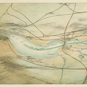
Jigsaw Puzzle : Manchester Ship Canal 2


![]()
Jigsaw Puzzles from Mary Evans Picture Library
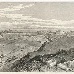
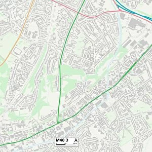
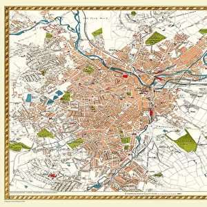
Manchester Ship Canal 2
Map showing the eastern end of the Canal, where it leaves Manchester and leads westwards towards the sea at Liverpool
Mary Evans Picture Library makes available wonderful images created for people to enjoy over the centuries
Media ID 601393
© Mary Evans Picture Library 2015 - https://copyrighthub.org/s0/hub1/creation/maryevans/MaryEvansPictureID/10120434
1883 Canal Canals Leads Liverpool Manchester Westwards
Jigsaw Puzzle (252 Pieces)
Discover the captivating beauty of Manchester's industrial heritage with our exquisite jigsaw puzzle from the Media Storehouse collection. Featuring the enchanting image "Manchester Ship Canal 2" by Mary Evans Picture Library from Mary Evans Prints Online, this puzzle transports you to the eastern end of the canal, where it leaves Manchester and embarks on its westward journey towards the sea at Liverpool. With intricate details and vibrant colors, this puzzle is a delightful challenge for puzzle enthusiasts of all ages. Immerse yourself in the rich history and engineering marvel of the Manchester Ship Canal as you piece together this stunning jigsaw puzzle.
Made in the USA, 252-piece puzzles measure 11" x 14" (27.9 x 35.5 cm). Every puzzle is meticulously printed on glossy photo paper, which has a strong 1.33 mm thickness. Delivered in a black storage cardboard box, these puzzles are both stylish and practical. (Note: puzzles contain small parts and are not suitable for children under 3 years of age.)
Jigsaw Puzzles are an ideal gift for any occasion
Estimated Product Size is 35.6cm x 28cm (14" x 11")
These are individually made so all sizes are approximate
Artwork printed orientated as per the preview above, with landscape (horizontal) orientation to match the source image.
EDITORS COMMENTS
This historical print captures a detailed map of the eastern end of the Manchester Ship Canal, showcasing its route from Manchester to Liverpool in Britain. Dating back to 1883, this intricate illustration provides a fascinating glimpse into the transportation history of the region.
The canal, which stretches westwards towards the sea at Liverpool, played a crucial role in connecting these two major cities and facilitating trade and commerce between them. The map highlights key points along the canal's path, offering insight into how goods were transported by ship through this important waterway.
With canals being an essential mode of transport during this time period, this print serves as a valuable historical document that sheds light on the significance of waterways in shaping Britain's industrial landscape. It also showcases Mary Evans Picture Library's dedication to preserving and sharing images that capture moments from our past.
Whether you have an interest in maritime history or simply appreciate beautifully crafted maps, this print is sure to captivate your imagination and spark curiosity about the rich heritage of canals in Britain. Display it proudly in your home or office as a conversation piece that celebrates our shared history.
MADE IN THE USA
Safe Shipping with 30 Day Money Back Guarantee
FREE PERSONALISATION*
We are proud to offer a range of customisation features including Personalised Captions, Color Filters and Picture Zoom Tools
SECURE PAYMENTS
We happily accept a wide range of payment options so you can pay for the things you need in the way that is most convenient for you
* Options may vary by product and licensing agreement. Zoomed Pictures can be adjusted in the Cart.