Home > Maps and Charts > World
1845, Mitchell Wall Map of the United States, partial Republic of Texas, topography

![]()
Wall Art and Photo Gifts from Liszt Collection
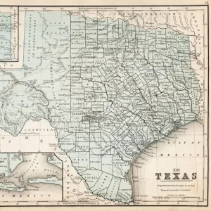
1845, Mitchell Wall Map of the United States, partial Republic of Texas, topography
1845, Mitchell Wall Map of the United States, partial Republic of Texas
Liszt Collection of nineteenth-century engravings and images to browse and enjoy
Media ID 14005115
© Artokoloro Quint Lox Limited
1845 Antique Map Atlas Chart Geographic Latitude Longitude Mappa Mundi Old Antique Plan Old Antique View Old Map Ols Antique Map Rare Old Maps Topo
FEATURES IN THESE COLLECTIONS
> Maps and Charts
> Early Maps
> Maps and Charts
> World
EDITORS COMMENTS
This print showcases the remarkable 1845 Mitchell Wall Map of the United States, offering a glimpse into the past with its depiction of the partial Republic of Texas. The map's topography is intricately detailed, providing a comprehensive understanding of the land's geographical features. Created by skilled cartographers and illustrators, this vintage piece seamlessly combines artistry and scientific accuracy. The Mitchell Wall Map takes us on a historical journey through time, evoking a sense of discovery and exploration. Its ancient charm is evident in every inch as it gracefully unfolds stories from yesteryears. The delicate paper texture adds to its allure, reminding us of an era when maps were cherished possessions. With its decorative elements and precise navigation aids such as latitude-longitude grids and charts, this antique treasure serves not only as an invaluable tool for travelers but also as a window into our world's rich history. It transports us back to an age when mappa mundi were revered for their ability to unlock new regions and expand our knowledge. As part of the Liszt Collection, this rare old map captures both the beauty and significance of cartography in preserving our past. While it may no longer guide modern-day journeys or serve commercial purposes, it remains an artistic testament to human curiosity about our planet's ever-changing landscape.
MADE IN THE USA
Safe Shipping with 30 Day Money Back Guarantee
FREE PERSONALISATION*
We are proud to offer a range of customisation features including Personalised Captions, Color Filters and Picture Zoom Tools
SECURE PAYMENTS
We happily accept a wide range of payment options so you can pay for the things you need in the way that is most convenient for you
* Options may vary by product and licensing agreement. Zoomed Pictures can be adjusted in the Cart.