Home > Oceania > Australia > Maps
Lines of Longitude 1683

![]()
Wall Art and Photo Gifts from Mary Evans Picture Library
Lines of Longitude 1683
Showing Africa, Europe, Asia, South Pole and part of Australia, the two hemispheres, the equator and the lines of Longitude
Mary Evans Picture Library makes available wonderful images created for people to enjoy over the centuries
Media ID 589250
© Mary Evans Picture Library 2015 - https://copyrighthub.org/s0/hub1/creation/maryevans/MaryEvansPictureID/10173761
1683 Equator Hemispheres Lines Longitude Maps Pole
FEATURES IN THESE COLLECTIONS
> Africa
> Related Images
> Asia
> Related Images
> Europe
> Related Images
> Maps and Charts
> Early Maps
> Maps and Charts
> World
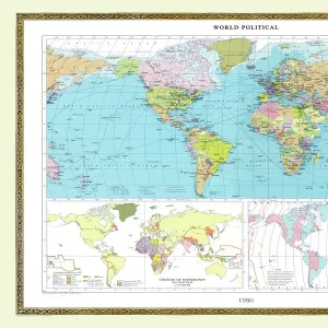
This historic map print, titled
EDITORS COMMENTS
Lines of Longitude," dates back to 1683 and offers a fascinating glimpse into the cartographic knowledge of the time. The map depicts the world as known during the late 17th century, with Africa, Europe, Asia, and a part of Australia clearly visible. The South Pole and the North Pole are also marked, with the former shown as a simple cross. The equator is clearly demarcated as the line separating the Northern and Southern Hemispheres. The most intriguing feature of this map is the representation of the lines of longitude. These meridians, which converge at the North and South Poles, were essential for navigators and explorers to determine their east-west position at sea. The map shows 15 degrees of longitude, with each degree marked by a letter, from A to O, starting at the Prime Meridian in Greenwich, England. This map is a testament to the advancements in cartography during the Age of Discovery. It reflects the growing understanding of the world's geography and the importance of longitude lines for navigation. The map's intricate details and accurate depiction of the known world make it an invaluable historical artifact, providing a window into the past and the explorers who shaped our understanding of the world." This map print, "Lines of Longitude," from 1683, offers a captivating look into the cartographic knowledge of the late 17th century. Africa, Europe, Asia, and a part of Australia are clearly visible, with the South Pole and North Pole marked. The equator separates the Northern and Southern Hemispheres, while the lines of longitude, converging at the poles, provide essential information for navigators. This map is a significant historical artifact, showcasing the advancements in cartography during the Age of Discovery and the growing understanding of the world's geography.
MADE IN THE USA
Safe Shipping with 30 Day Money Back Guarantee
FREE PERSONALISATION*
We are proud to offer a range of customisation features including Personalised Captions, Color Filters and Picture Zoom Tools
SECURE PAYMENTS
We happily accept a wide range of payment options so you can pay for the things you need in the way that is most convenient for you
* Options may vary by product and licensing agreement. Zoomed Pictures can be adjusted in the Cart.