Home > Oceania > Australia > Maps
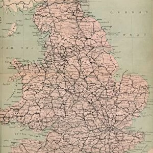
Map of Victoria and Tasmania

![]()
Wall Art and Photo Gifts from Heritage Images
Map of Victoria and Tasmania
Map of Victoria and Tasmania. Map showing a southern section of Australia, Melbourne, the Bass Strait and the island of Tasmania. Plate 107 from The Times Atlas
Heritage Images features heritage image collections
Media ID 15464464
© The Print Collector / Heritage-Images
Australia Cartography Coastline Map Making Melbourne South Strait Tasmania Victoria Bass Strait
FEATURES IN THESE COLLECTIONS
> Oceania
> Australia
> Melbourne
EDITORS COMMENTS
This print showcases a historical treasure, the "Map of Victoria and Tasmania". A true testament to the art of cartography, this map depicts a southern section of Australia with intricate detail. Melbourne, the bustling city known for its vibrant culture and stunning architecture, is prominently featured on this map. The Bass Strait, separating mainland Australia from the enchanting island of Tasmania, is also beautifully illustrated. The colors used in this print bring life to the geographical features portrayed. From the rugged coastlines to the vast stretches of land, every element has been meticulously captured by an unknown artist. This piece serves as a visual reminder of how far we have come in our understanding and representation of our world. As we gaze upon this remarkable work, it evokes a sense of wonder about these regions' rich history and natural beauty. It invites us to explore further into their depths - from Victoria's diverse landscapes to Tasmania's untamed wilderness. Preserved by The Print Collector and now made available through Heritage Images, this photograph allows us to appreciate not only its aesthetic value but also its historical significance. Let it serve as a reminder that maps are not mere tools for navigation; they are windows into our past and gateways towards discovery.
MADE IN THE USA
Safe Shipping with 30 Day Money Back Guarantee
FREE PERSONALISATION*
We are proud to offer a range of customisation features including Personalised Captions, Color Filters and Picture Zoom Tools
SECURE PAYMENTS
We happily accept a wide range of payment options so you can pay for the things you need in the way that is most convenient for you
* Options may vary by product and licensing agreement. Zoomed Pictures can be adjusted in the Cart.