Home > Africa > Cameroon > Maps
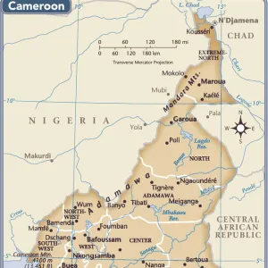
Le Cameroun Francais; Carte du Cameroun franco-britannique, 1916. Creator: Unknown

![]()
Wall Art and Photo Gifts from Heritage Images
Le Cameroun Francais; Carte du Cameroun franco-britannique, 1916. Creator: Unknown
Le Cameroun Francais; Carte du Cameroun franco-britannique. 1916. From "Collection de la Guerre IV. L'Illustration Tome CXLVII. La Guerre Juillet, Aout, Septembre, Octobre, Novembre, Decembre 1916"
Heritage Images features heritage image collections
Media ID 36291297
© The Print Collector/Heritage Images
Cameroon Cartography Lillustration Map Making Mapmaking Partition
FEATURES IN THESE COLLECTIONS
> Africa
> Cameroon
> Related Images
> Africa
> Related Images
> Historic
> World War I and II
> World War I
> Historic
> World War I and II
> Maps and Charts
> Related Images
Le Cameroun Francais; Carte du Cameroun franco-britannique,
EDITORS COMMENTS
a black and white map print from 1916, offers a glimpse into the complex political landscape of Africa during the First World War. The map, which is part of the "Collection de la Guerre IV. L'Illustration Tome CXLVII. La Guerre Juillet, Aout, Septembre, Octobre, Novembre, Decembre 1916," depicts the territories of Cameroon under both French and British control. At the turn of the 20th century, Europe's colonial powers, including France and Britain, engaged in a fierce competition to claim territories in Africa. The Scramble for Africa, as it came to be known, resulted in the partition of the African continent among various European powers. Cameroon, located on the west coast of Central Africa, was a prized possession due to its rich natural resources and strategic location. The map reflects the outcome of the 1911 Anglo-French Agreement, which divided Cameroon into two territories: French Cameroon to the west and British Cameroon to the east. The map's title, "Le Cameroun Francais; Carte du Cameroun franco-britannique," highlights the Franco-British nature of the region at the time. The mapmaking process during the colonial era was a significant aspect of the colonial project, as it served to legitimize and solidify European claims over territories. The map's creation and publication in 1916, during the First World War, underscore the ongoing geopolitical struggles and tensions in Africa and beyond. The map's unknown creator remains a mystery, but their work provides valuable insight into the historical context of the First World War and the complexities of colonialism in Africa. The map's imagery, reminiscent of the era, adds to its historical significance and authenticity. Overall, this map print is a testament to the enduring impact of colonialism on Africa and the world at large.
MADE IN THE USA
Safe Shipping with 30 Day Money Back Guarantee
FREE PERSONALISATION*
We are proud to offer a range of customisation features including Personalised Captions, Color Filters and Picture Zoom Tools
SECURE PAYMENTS
We happily accept a wide range of payment options so you can pay for the things you need in the way that is most convenient for you
* Options may vary by product and licensing agreement. Zoomed Pictures can be adjusted in the Cart.