Home > Europe > United Kingdom > Scotland > Maps
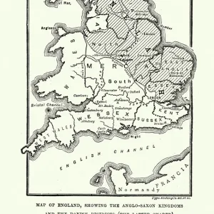
Danish Invasion of Wessex 876-878, (1935)
")
![]()
Wall Art and Photo Gifts from Heritage Images
Danish Invasion of Wessex 876-878, (1935)
Danish Invasion of Wessex 876-878, (1935). Map of England, Wales and part of Scotland, showing significant locations (with contemporary place names) during the invasions from Scandinavia. From A History of the Anglo-Saxons, Vol. II, by R. H. Hodgkin. [The Clarendon Press, Oxford, 1935]
Heritage Images features heritage image collections
Media ID 15466764
© The Print Collector / Heritage-Images
9th Century Anglo Saxon County Wessex Danish
FEATURES IN THESE COLLECTIONS
> Europe
> United Kingdom
> England
> Maps
> Europe
> United Kingdom
> England
> Oxford
> Europe
> United Kingdom
> Scotland
> Maps
> Europe
> United Kingdom
> Wales
> Maps
EDITORS COMMENTS
This print takes us back to the tumultuous period of the Danish Invasion of Wessex in the late 9th century. The map, beautifully rendered with vibrant colors, showcases England, Wales, and a part of Scotland during this historic conflict. With contemporary place names carefully marked, it offers a window into the significant locations that witnessed fierce battles and strategic maneuvers. The image is sourced from "A History of the Anglo-Saxons" by R. H. Hodgkin, published in 1935 by The Clarendon Press in Oxford. It serves as a testament to how historical records can transport us across centuries. In this snapshot frozen in time, we see an army on the move - warriors clad in armor marching through treacherous terrains as they fought for control over Wessex. This visual representation captures not only their physical journey but also hints at their determination and resilience amidst war-torn landscapes. As we gaze upon this remarkable piece of history captured on paper nearly a millennium later, it reminds us of our connection to those who came before us. It prompts reflection on how conflicts shape nations and societies throughout time. This print is more than just an artistic depiction; it encapsulates a pivotal moment when two cultures clashed fiercely for power and dominance. Its significance lies not only in its aesthetic appeal but also in its ability to ignite curiosity about our shared pasts and inspire further exploration into these fascinating chapters of human history.
MADE IN THE USA
Safe Shipping with 30 Day Money Back Guarantee
FREE PERSONALISATION*
We are proud to offer a range of customisation features including Personalised Captions, Color Filters and Picture Zoom Tools
SECURE PAYMENTS
We happily accept a wide range of payment options so you can pay for the things you need in the way that is most convenient for you
* Options may vary by product and licensing agreement. Zoomed Pictures can be adjusted in the Cart.