Fraud Blocker Skip to main content

Surveyor Collection

"Surveyors: Mapping the World

Background imageSurveyor Collection: SURVEYORS. Surveyors at work on land and sea. Colored German engraving, 1594

SURVEYORS. Surveyors at work on land and sea. Colored German engraving, 1594

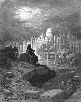
Background imageSurveyor Collection: The New Zealander, 1872. Creator: Gustave Doré

The New Zealander, 1872. Creator: Gustave Doré
The New Zealander, 1872. A figure sits on the banks of the River Thames contemplating the downfall of the city. From, " LONDON. A Pilgrimage" by Gustave Dore and Blanchard Jerrold

Background imageSurveyor Collection: SURVEYING, 1594. Surveyors taking sightings on land and sea. Line engraving, German, 1594

SURVEYING, 1594. Surveyors taking sightings on land and sea. Line engraving, German, 1594

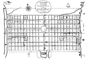
Background imageSurveyor Collection: The first engraved plan of the city of Philadelphia by Thomas Holme, 1683

The first engraved plan of the city of Philadelphia by Thomas Holme, 1683
PHILADELPHIA: MAP, 1683. The first engraved plan of the city of Philadelphia by Thomas Holme, 1683

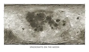
Background imageSurveyor Collection: Spacecraft on the Moon, lunar map

Spacecraft on the Moon, lunar map
Spacecraft on the Moon. Map showing coloured markers for 34 spacecraft that impacted or landed on the Moon from the 1960s onwards

Background imageSurveyor Collection: (1732-1799). First President of the United States. George Washington surveying Lord Fairfaxs land

(1732-1799). First President of the United States. George Washington surveying Lord Fairfaxs land: wood engraving
GEORGE WASHINGTON (1732-1799). First President of the United States. George Washington surveying Lord Fairfaxs land: wood engraving, American, 1881

Background imageSurveyor Collection: Map of the kingdoms of Granada and Murcia (Granata

Map of the kingdoms of Granada and Murcia (Granata et Murcia regna) by W. Blaeu. Decorated with the Arms of both States, the figure of a surveyor and a naval combat. Published in Amsterdam, 1635

Background imageSurveyor Collection: Union Workhouse, Wellington, Somerset

Union Workhouse, Wellington, Somerset
The Wellington Union workhouse on North Street, Wellington, Somerset. A group of local children stand outside. The workhouse, designed by County Surveyor, Richard Carver, was erected in 1836-7

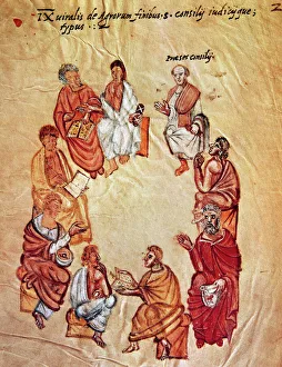
Background imageSurveyor Collection: Surveyors sitting in a circle during a meeting. Miniature of

Surveyors sitting in a circle during a meeting. Miniature of the 14th century

Background imageSurveyor Collection: GEORGE WASHINGTON (1732-1799). First President of the United States

GEORGE WASHINGTON (1732-1799). First President of the United States. Young George Washington as a surveyor. Color engraving, 19th century

Background imageSurveyor Collection: PPRE2A-00193

PPRE2A-00193
Young George Washington working as a surveyor in Virginia. Hand-colored woodcut of a 19th-century illustration

Background imageSurveyor Collection: PBLA2R-00002

PBLA2R-00002
Benjamin Banneker. Hand-colored 19th-century woodcut reproduction of an earlier portrait, digitally retouched

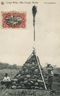
Background imageSurveyor Collection: Trigonometry Point

Trigonometry Point
A Trigonometry Point at Buvita in the Belgium Congo, topped off with a broom!

Background imageSurveyor Collection: Young Washington, Surveyor

Young Washington, Surveyor
LLM455716 Young Washington, Surveyor by North American, (19th century); Private Collection; (add.info.: Young Washington, Surveyor)

Background imageSurveyor Collection: Admiral Teddy Evans, (1881-1957), British naval officer and Antarctic explorer, 1916

Admiral Teddy Evans, (1881-1957), British naval officer and Antarctic explorer, 1916
Admiral Edward Ratcliffe Garth Russell Evans, 1st Baron Mountevans (1881-1957), known as Teddy Evans, was a British naval officer and Antarctic explorer, 1916

Background imageSurveyor Collection: NEW YORK MAP, 1730. The Bradford Map or Lyne Survey of 1730. Line engraving, 1731

NEW YORK MAP, 1730. The Bradford Map or Lyne Survey of 1730. Line engraving, 1731

Background imageSurveyor Collection: William Low

William Low, surveyor and civil engineer. Low formed the Channel Tunnel Company and was the first to make realistic plans for the construction of a tunnel

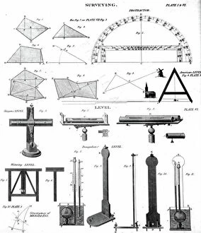
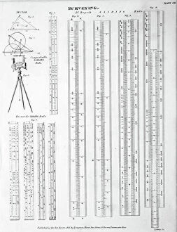
Background imageSurveyor Collection: Collection of Surveying tools and methods for measurements (engraving)

Collection of Surveying tools and methods for measurements (engraving)
5616447 Collection of Surveying tools and methods for measurements (engraving); (add.info.: Collection of Surveying tools and methods for measurements)

Background imageSurveyor Collection: Thoreau's birthplace, the Wheeler-Minot Farmhouse in Concord, Massachusetts

Thoreau's birthplace, the Wheeler-Minot Farmhouse in Concord, Massachusetts, United States of America
5614301 Thoreau's birthplace, the Wheeler-Minot Farmhouse in Concord, Massachusetts, United States of America; (add.info.: Thoreau's birthplace, the Wheeler-Minot Farmhouse in Concord)

Background imageSurveyor Collection: Benjamin Wright, ' father of civil engineering,' 1800s

Benjamin Wright, " father of civil engineering," 1800s
NWI4948857 Benjamin Wright, " father of civil engineering," 1800s.; (add.info.: Benjamin Wright, " father of civil engineering," 1800s.); Photo © North Wind Pictures.

Background imageSurveyor Collection: The burial of William John Wills

The burial of William John Wills
3585962 The burial of William John Wills; (add.info.: Illustration depicting the burial of William John Wills (1834-1861) a British surveyor

Background imageSurveyor Collection: Vincent Wing

Vincent Wing
3585953 Vincent Wing; (add.info.: Portrait of Vincent Wing (1619-1668) an English astrologer and astronomer, as well as a land surveyor. Dated 17th Century.); Universal History Archive/UIG.

Background imageSurveyor Collection: Illustration depicting a Surveyor's Quadrant, 1765 (engraving)

Illustration depicting a Surveyor's Quadrant, 1765 (engraving)
5616450 Illustration depicting a Surveyor's Quadrant, 1765 (engraving); Universal History Archive/UIG.

Background imageSurveyor Collection: Collection of Surveying tools and methods for measurements (engraving)

Collection of Surveying tools and methods for measurements (engraving)
5616445 Collection of Surveying tools and methods for measurements (engraving); (add.info.: Collection of Surveying tools and methods for measurements)

Background imageSurveyor Collection: Everest's Theodolite

Everest's Theodolite
5616443 Everest's Theodolite; (add.info.: Illustration depicting George Everest's Theodolite, a precise level. George Everest (1790-1866) a Welsh surveyor and geographer

Background imageSurveyor Collection: Grove Karl Gilbert, Chief of US Geologic Survey in the late 1800s

Grove Karl Gilbert, Chief of US Geologic Survey in the late 1800s
NWI4949315 Grove Karl Gilbert, Chief of US Geologic Survey in the late 1800s.; (add.info.: Grove Karl Gilbert, Chief of US Geologic Survey in the late 1800s.); Photo © North Wind Pictures.

Background imageSurveyor Collection: Brooklyn Suspension Bridge, illustration 1883

Brooklyn Suspension Bridge, illustration 1883
2604032 Brooklyn Suspension Bridge, illustration 1883; (add.info.: Brooklyn Suspension Bridge, New York: Designed and built by JA Roebling and his son WA Roebling, opened 1883)

Background imageSurveyor Collection: A scene from Burke and Wills' expedition

A scene from Burke and Wills' expedition
5310337 A scene from Burke and Wills' expedition; (add.info.: Engraving depicting a scene from Burke and Wills' expedition of Australia)

Background imageSurveyor Collection: Collection of Surveying tools and methods for measurements (engraving)

Collection of Surveying tools and methods for measurements (engraving)
5616449 Collection of Surveying tools and methods for measurements (engraving); (add.info.: Collection of Surveying tools and methods for measurements)

Background imageSurveyor Collection: Collection of Surveying tools and methods for measurements (engraving)

Collection of Surveying tools and methods for measurements (engraving)
5616448 Collection of Surveying tools and methods for measurements (engraving); (add.info.: Collection of Surveying tools and methods for measurements)

Background imageSurveyor Collection: Union Engineer with transit

Union Engineer with transit
3056303 Union Engineer with transit; Private Collection; (add.info.: American Civil War, Union Engineer with transit); © Don Troiani. All Rights Reserved 2022.

Background imageSurveyor Collection: William John Wills

William John Wills
3585963 William John Wills; (add.info.: Portrait of William John Wills (1834-1861) a British surveyor, trained surgeon and second-in-command of the ill-fated Burke

Background imageSurveyor Collection: Illustration depicting a surveyor measuring a water level. 1887

Illustration depicting a surveyor measuring a water level. 1887
5311476 Illustration depicting a surveyor measuring a water level. 1887; (add.info.: Date: 1887); Universal History Archive/UIG.

Background imageSurveyor Collection: A Photographic Theodolite

A Photographic Theodolite
5616444 A Photographic Theodolite; (add.info.: Illustration depicting a Photographic Theodolite. Dated 19th Century. 01/01/1880); Universal History Archive/UIG.

Background imageSurveyor Collection: Collection of Surveying tools and methods for measurements (engraving)

Collection of Surveying tools and methods for measurements (engraving)
5616446 Collection of Surveying tools and methods for measurements (engraving); (add.info.: Collection of Surveying tools and methods for measurements)

Background imageSurveyor Collection: Wurdemann's Theodolite

Wurdemann's Theodolite
5616442 Wurdemann's Theodolite; (add.info.: Illustration depicting William Wurdemann's Theodolite, a precise level with a graduated horizontal circle. Dated 19th Century)

Background imageSurveyor Collection: James Geddes, surveyor and engineer for the Erie Canal

James Geddes, surveyor and engineer for the Erie Canal
NWI4948848 James Geddes, surveyor and engineer for the Erie Canal.; (add.info.: James Geddes, surveyor and engineer for the Erie Canal.); Photo © North Wind Pictures.

Background imageSurveyor Collection: Baldwin Wake Walker

Baldwin Wake Walker
3586364 Baldwin Wake Walker; (add.info.: Portrait of Baldwin Wake Walker (1802-1876) a British Surveyor of the British Navy. Dated 19th Century.); Universal History Archive/UIG.

Background imageSurveyor Collection: 4th grade students of the Irkutsk Mining School with a teacher, 1914. Creator: Unknown

4th grade students of the Irkutsk Mining School with a teacher, 1914. Creator: Unknown
4th grade students of the Irkutsk Mining School with a teacher, 1914. From a collection of 136 photographs of Irkutsk from the late nineteenth and early twentieth centuries

Background imageSurveyor Collection: The late Colonel A. Strange, F.R.S. 1876. Creator: Unknown

The late Colonel A. Strange, F.R.S. 1876. Creator: Unknown
The late Colonel A. Strange, F.R.S. 1876. Engraving from a photograph by Messrs. Maull and Co. Colonel Alexander Strange...did much very good service in the work of the trigonometrical survey in

Background imageSurveyor Collection: Portrait of Barend Goudriaan Ariesz. 1776. Creator: Cornelis van Cuylenburg

Portrait of Barend Goudriaan Ariesz. 1776. Creator: Cornelis van Cuylenburg
Portrait of Barend Goudriaan Ariesz. 1776

Background imageSurveyor Collection: Ernest George Fischer, Chief of Instrument Division, Coastal Geodetic Survey, 1914

Ernest George Fischer, Chief of Instrument Division, Coastal Geodetic Survey, 1914. Creator: Harris & Ewing
Ernest George Fischer, Chief of Instrument Division, Coastal Geodetic Survey, 1914. (Chief of Instrument Division 1907-1921)

Background imageSurveyor Collection: Panama Canal, 1913. Creator: Harris & Ewing. Panama Canal, 1913. Creator: Harris & Ewing

Panama Canal, 1913. Creator: Harris & Ewing. Panama Canal, 1913. Creator: Harris & Ewing
Panama Canal, 1913. The Panama Canal project was one of the largest and most difficult engineering projects ever undertaken

Background imageSurveyor Collection: Panorama of New Zealand - Bivouack of Surveyors, 1850. Creator: Unknown

Panorama of New Zealand - Bivouack of Surveyors, 1850. Creator: Unknown
Panorama of New Zealand - Bivouack of Surveyors, 1850. Display in London:..painted by Mr. S. C. Brees, from drawings made by him during his location in New Zealand as principal engineer

Background imageSurveyor Collection: Happy Hours in Camp G and B&M Engineers Corps and Visitors, 1889. Creator: John C. H. Grabill

Happy Hours in Camp G and B&M Engineers Corps and Visitors, 1889. Creator: John C. H. Grabill
Happy Hours in Camp G and B&M Engineers Corps and Visitors, 1889. Small group of men and women and two deer in front of a tent. Some of the men are playing musical instruments

Background imageSurveyor Collection: Engineers Corps camp and visitors, 1889. Creator: John C. H. Grabill

Engineers Corps camp and visitors, 1889. Creator: John C. H. Grabill
Engineers Corps camp and visitors, 1889. Row of fifteen people and two deer in front of a tent. Some of the men are holding measuring poles and or standing next to surveyors transits on tripods

Background imageSurveyor Collection: Deadwood Central RR Engineer Corps, 1888. Creator: John C. H. Grabill

Deadwood Central RR Engineer Corps, 1888. Creator: John C. H. Grabill
Deadwood Central RR Engineer Corps, 1888. Outdoor group portrait of ten railroad engineers and a dog, posing with surveyors transits on tripods and measuring rods, on the side of a mountain

Background imageSurveyor Collection: Deadwood Central RR Engineer Corps, 1888. Creator: John C. H. Grabill

Deadwood Central RR Engineer Corps, 1888. Creator: John C. H. Grabill
Deadwood Central RR Engineer Corps, 1888. Outdoor group portrait of ten railroad engineers, wearing suits and hats, and a dog, posing in a row with surveyors transits on tripods and measuring rods


All Professionally Made to Order for Quick Shipping

"Surveyors: Mapping the World, Land and Sea Through Time" Step back in time to 1594 with a colored German engraving showcasing surveyors diligently working on land and sea. Their meticulous efforts capture the essence of early surveying techniques. In another line engraving from the same year, German they are seen taking sightings on both land and sea. This glimpse into their world offers a fascinating insight into the tools and methods used during this era. Traveling forward to 1872, Gustave Doré's masterpiece "The New Zealander" depicts a scene where surveyors play an integral role in shaping new territories. Their expertise is crucial in charting unexplored lands. Thomas Holme's engraved plan of Philadelphia from 1683 showcases how early surveyors laid the foundation for one of America's most iconic cities. Their precision and attention to detail can be seen etched onto this historical map. Even beyond Earth's boundaries, surveying remains essential. The lunar map featuring spacecraft on the Moon exemplifies how even celestial bodies require careful examination by skilled professionals. George Washington, renowned as America's first President, was also an accomplished surveyor. A wood engraving from 1881 captures him meticulously measuring Lord Fairfax's vast land holdings—an important chapter in his life before politics beckoned. From ancient kingdoms to modern workhouses like Wellington's Union Workhouse in Somerset, maps have always played a vital role in understanding our surroundings. Surveyors' contributions ensure accurate depictions that aid navigation and planning alike. Young George Washington himself began his journey as a surveyor—a profession that would shape his destiny as he embarked upon greatness later in life. Color engravings from the 19th century immortalize this formative period for one of history's greatest leaders. Beyond terrestrial landscapes, Admiral Teddy Evans stands tall among British naval officers and Antarctic explorers.