Fraud Blocker Skip to main content

Louisiana Territory Collection

The Louisiana Territory played a pivotal role in the growth of the United States to 1853

Background imageLouisiana Territory Collection: PEXP2D-00013

PEXP2D-00013
Explorers Meriwether Lewis and William Clark with their Native American guide Sacagawea. Digital photograph of a bronze statue in Charlottesville Virginia

Background imageLouisiana Territory Collection: Growth of the United States to 1853

Growth of the United States to 1853
U.S. map, showing territorial growth to 1853. Printed color lithograph of a 19th-century illustration

Background imageLouisiana Territory Collection: Native Americans meet Lewis and Clark at Council Bluffs

Native Americans meet Lewis and Clark at Council Bluffs
Lewis and Clark meeting with Native Americans at Council Bluffs, Iowa. Hand-colored woodcut by Patrick Goss, a member of the expedition

Background imageLouisiana Territory Collection: US territorial acquisition during the 1800s

US territorial acquisition during the 1800s
Map showiing the territorial growth of the continental US 1776 to 1899. Hand-colored woodcut of a 19th-century illustration

Background imageLouisiana Territory Collection: Meriwether Lewis shoots a Native American for disobedience, Corps of Discovery expedition

Meriwether Lewis shoots a Native American for disobedience, Corps of Discovery expedition
NWI4712736 Meriwether Lewis shoots a Native American for disobedience, Corps of Discovery expedition.; (add.info.: Meriwether Lewis shoots a Native American for disobedience)

Background imageLouisiana Territory Collection: USA territory origins - Map of territorial acquisition by the United States

USA territory origins - Map of territorial acquisition by the United States
NWI4712632 USA territory origins - Map of territorial acquisition by the United States.; (add.info.: USA territory origins - Map of territorial acquisition by the United States)

Background imageLouisiana Territory Collection: Frontiersmen on the upper Missouri River, 1800s

Frontiersmen on the upper Missouri River, 1800s
Half-breeds and French voyageurs towing a boat in the upper Missouri River, 1800s. Hand-colored woodcut of a 19th-century illustration

Background imageLouisiana Territory Collection: EXPL2A-00269

EXPL2A-00269
Meriwether Lewis and William Clark expedition losing notes and specimens in a canoe accident on the upper Missouri River. Hand-colored woodcut reproduction of sketch by Patrick Goss

Background imageLouisiana Territory Collection: Fort Mandan constructed by Lewis and Clark, 1803

Fort Mandan constructed by Lewis and Clark, 1803
Lewis and Clark expedition overwintering along the Missouri River near a Mandan village, 1803-1804. Hand-colored woodcut of a Patrick Goss drawing, a member of the expedition

Background imageLouisiana Territory Collection: EXPL2A-00035

EXPL2A-00035
Map of the Lewis and Clark route across Louisiana Territory, 1804-1806. Hand-colored woodcut of a 19th-century illustration

Background imageLouisiana Territory Collection: Lolo Creek in the Bitterroot Range, Montana

Lolo Creek in the Bitterroot Range, Montana
Lolo Creek on Lewis and Clarks trail over the Bitterroot Mountains in Montana. Photograph

Background imageLouisiana Territory Collection: North American colonies in 1733

North American colonies in 1733
European claims in North America in 1733, when the last English colony, Georgia, was founded. Color lithograph

Background imageLouisiana Territory Collection: EXPL2A-00339

EXPL2A-00339
William Clarks letter accepting Lewiss invitation to join the Corps of Discovery expedition, dated Clarksville 1803. Printed halftone reproduction with a watercolor wash

Background imageLouisiana Territory Collection: EXPL2A-00351

EXPL2A-00351
Title page of the first publication of Lewis and Clarks journal and notes, 1814. Woodcut with a watercolor wash

Background imageLouisiana Territory Collection: Lewis and Clark monument at Fort Benton, Montana

Lewis and Clark monument at Fort Benton, Montana
Statue of Sacagawea guiding Lewis and Clark at Fort Benton, Montana. Photograph

Background imageLouisiana Territory Collection: EXPL2P-00031

EXPL2P-00031
Fort Mandan, a reconstructed Lewis and Clark campsite on the Missouri River, North Dakota. Photograph

Background imageLouisiana Territory Collection: PEXP2D-00014

PEXP2D-00014
Explorers Meriwether Lewis and William Clark with their Native American guide Sacagawea. Digital photograph of a bronze statue in Charlottesville Virginia

Background imageLouisiana Territory Collection: PEXP2D-00011

PEXP2D-00011
Explorers Meriwether Lewis and William Clark with their Native American guide Sacagawea. Digital photograph of a bronze statue in Charlottesville, Virginia

Background imageLouisiana Territory Collection: EXPL2A-00133

EXPL2A-00133
Lewis and Clark expedition trying to make friends with Native Americans during their exploration of Louisiana Territory. Hand-colored halftone of a 19th-century illustration

Background imageLouisiana Territory Collection: Tobacco Root Mountains and the Jefferson River, Montana

Tobacco Root Mountains and the Jefferson River, Montana
Jefferson River, named for Thomas Jefferson by Lewis and Clark. Photograph

Background imageLouisiana Territory Collection: EXPL2A-00039

EXPL2A-00039
Map of the US in 1792, showing colonial claims on Oregon Territory. Printed color halftone of a 19th century illustration

Background imageLouisiana Territory Collection: EXPL2A-00038

EXPL2A-00038
Map of the U.S. boundary disputes with Spain and Great Britain, 1810-1812. Printed color lithograph of a 19th-century illustration

Background imageLouisiana Territory Collection: Great Falls on the Missouri River

Great Falls on the Missouri River
Bison overlooking the Great Falls of the Missouri River, Montana, before settlement. Hand-colored woodcut of a 19th-century illustration

Background imageLouisiana Territory Collection: EXPL2A-00168

EXPL2A-00168
William Clarks sketch of an evergreen shrub leaf in the Lewis and Clark expedition diary, 1806. Hand-colored halftone reproduction of a 19th-century photograph of Clarks handwritten page

Background imageLouisiana Territory Collection: EXPL2A-00167

EXPL2A-00167
William Clarks sketch of Flathead Indians in his diary of the Lewis and Clark expedition, 1804-1806 Hand-colored halftone reproduction of a 19th-century photograph of Clarks handwritten page

Background imageLouisiana Territory Collection: William Clarks invitation from Meriwether Lewis, 1804

William Clarks invitation from Meriwether Lewis, 1804
Meriwether Lewiss letter inviting William Clark to join the expedition to explore the Louisiana Territory. Printed halftone reproduction with a watercolor wash

Background imageLouisiana Territory Collection: EXPL2P-00037

EXPL2P-00037
Fort Mandan, reconstructed Lewis and Clark campsite on Missouri River, North Dakota. Photograph

Background imageLouisiana Territory Collection: EXPL2P-00061

EXPL2P-00061
Lewis and Clark trail over Lolo Pass, Bitterroot Mountains, Montana. Photograph

Background imageLouisiana Territory Collection: PEXP2A-00011

PEXP2A-00011
Portrait of explorer William Clark. Hand colored engraving of a 19th century painting

Background imageLouisiana Territory Collection: PEXP2A-00012

PEXP2A-00012
Portrait of explorer Meriwether Lewis. Hand colored engraving of a 19th century painting

Background imageLouisiana Territory Collection: EXPL2A-00124

EXPL2A-00124
Fort Rozalie des Natchez on the Mississippi River 1700s - North is to the right. Hand-colored woodcut of a map published in 1770. Fleuve Saint Louis was the French name for the Mississippi River

Background imageLouisiana Territory Collection: EXPL2A-00118

EXPL2A-00118
LaSalle at the mouth of the Mississippi River claims Louisiana for France 1682. Hand-colored woodcut of a 19th-century illustration

Background imageLouisiana Territory Collection: EXPL2A-00117

EXPL2A-00117
Sketch by William Clark of Cock of the Plains in the Lewis and Clark expedition diary. Hand-colored halftone of a 19th-century reproduction of the diary

Background imageLouisiana Territory Collection: EXPL2A-00016

EXPL2A-00016
Hennepins map of New France and Louisiana - La Carte de la Nouvelle France, 1683. Hand-colored 19th-century woodcut reproduction of the original map

Background imageLouisiana Territory Collection: EXPL2A-00092

EXPL2A-00092
Lewis and Clark shoot a grizzly bear, unknown to whites, during their exploration of Louisiana Territory. Hand-colored woodcut reproduction of sketch by Patrick Goss

Background imageLouisiana Territory Collection: EXPL2A-00166

EXPL2A-00166
William Clarks sketch of a trout in the Lewis and Clark expedition diary. Hand-colored halftone reproduction of a 19th-century photograph of Clarks handwritten page

Background imageLouisiana Territory Collection: EXPL2A-00143

EXPL2A-00143
La Salle landing in Matagorda Bay Texas to colonize Louisiana Terrritory and the Mississippi valley area, 1685. Hand-colored 19th-century woodcut reproduction of an earlier illustration

Background imageLouisiana Territory Collection: Clark Fork, Montana

Clark Fork, Montana
Clark Fork River, named for William Clark, named by Lewis and Clark expedition in Montana. Photograph

Background imageLouisiana Territory Collection: EXPL2A-00041

EXPL2A-00041
Map of territorial growth of the United States from 1783-1867. Printed color lithograph of a 19th-century illustration

Background imageLouisiana Territory Collection: EXPL2A-00062

EXPL2A-00062
Map of the Louisiana Purchase as understood in 1803, later modified by treaty. Printed color lithograph of a 19th-century illustration


All Professionally Made to Order for Quick Shipping

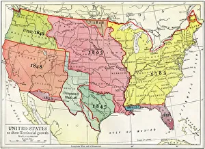
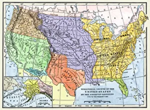
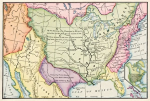
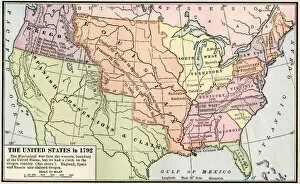
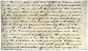
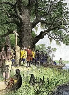
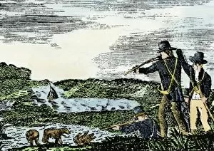
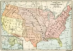
The Louisiana Territory played a pivotal role in the growth of the United States to 1853. Through territorial acquisitions during the 1800s, such as PEXP2D-00013, this vast region became an integral part of American expansion. Native Americans encountered Lewis and Clark at Council Bluffs, marking a significant moment in history captured by EXPL2A-00269. Frontiersmen on the upper Missouri River in the 1800s exemplified the spirit of exploration and adventure that characterized this era. Fort Mandan, constructed by Lewis and Clark in 1803 (EXPL2A-00035), served as a vital outpost for their expedition. Lolo Creek winding through Montana's Bitterroot Range showcases the natural beauty found within this territory. From its early days as North American colonies in 1733 to becoming a symbol of westward expansion with landmarks like Lewis and Clark monument at Fort Benton (EXPL2A-00351), Louisiana Territory holds immense historical significance. As America expanded its borders, it embraced new cultures while shaping its own identity. The Louisiana Territory stands as a testament to both Native American heritage and pioneering spirit that defined our nation's past.