
Louisiana Purchase Collection
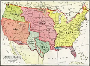
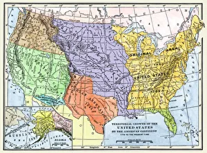
The Louisiana Purchase, made in 1803, marked a significant milestone in the growth of the United States


All Professionally Made to Order for Quick Shipping
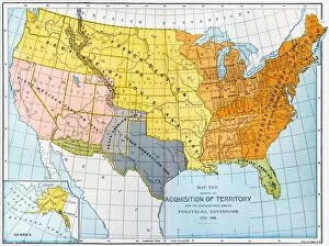
The Louisiana Purchase, made in 1803, marked a significant milestone in the growth of the United States. Under its wings, everything prospered as new territories were acquired and explored. One captivating view was that of the city of New Orleans, a bustling hub at the heart of this expansion. The PEXP2D-00013 map from 1820 showcases how these territorial acquisitions transformed the United States. Drawing on Lewis and Clark's geographical discoveries, it highlights the vastness of this newfound land. As we delve into history, we come across stunning watercolor paintings depicting life during this era. The stone walls on the Upper Missouri in 1832-34 provide a glimpse into frontier living. Encampments along the Missouri River in 1834 show us how travelers adapted to their surroundings. Amongst these scenes are portraits capturing Native American tribes like Pasesick-Kaskutau and Mato-Tope adorned with symbols representing their warlike deeds. Piegan Blackfeet Man stands proud as an embodiment of his culture and heritage. Viewing Blackbird's Grave on the Missouri River between 1832-34 transports us back to a time when nature dominated landscapes yet to be tamed by settlers' hands. And then there is Pehriska-Ruhpa, a Hidatsa warrior dressed for Dog Dance festivities in 1834 – showcasing traditions that have endured through generations. Through these images and stories emerges an understanding of how US territory expanded during the early 19th century. The Louisiana Purchase opened doors to uncharted possibilities while shaping America's destiny for years to come.