
Dunbartonshire Collection
"Dunbartonshire: A Journey Through Time and Beauty" Step back in time with the Old County Map of Dunbartonshire, formally called Dumbartonshire


All Professionally Made to Order for Quick Shipping
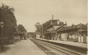
"Dunbartonshire: A Journey Through Time and Beauty" Step back in time with the Old County Map of Dunbartonshire, formally called Dumbartonshire, Scotland 1847 by A&C Black. This captivating map unveils the rich history that shaped this remarkable region. Discover the spiritual heart at Robert Burns Church, a testament to Scotland's literary genius. Its grandeur stands as a reminder of the enduring legacy left by this beloved poet. Travel further into the past with the Old Map of the County of Dumbarton from the Philips Handy Atlas of 1882. Uncover forgotten tales and hidden gems scattered across this enchanting land. Indulge your senses at The Pier, Luss, Loch Lomond, Scotland. Let its serene beauty wash over you as you gaze upon breathtaking views that have inspired artists for centuries. Marvel at Rock Sculpturing recently discovered at Bowling, Dumbartonshire (litho). Witness ancient artistry etched into stone and contemplate its mysterious origins. Embark on a journey through time aboard Railway Station (Glasgow, Dumbarton and Helensburgh Railway (GDHR)), Bearsden, Glasgow. Feel the excitement build as you traverse historic tracks once bustling with passengers from all walks of life. Navigate through modernity with Postcode Sector Map sheet 25 Glasgow and Clyde. Explore vibrant neighborhoods brimming with culture and diversity that make up this dynamic area. Experience tranquility at Railway Station Hillfoot, Bearsden, Scotland. Let nature's symphony soothe your soul as you bask in peaceful surroundings away from city bustle. Follow The River Leven to Balloch, Dunbartonshire where scenic beauty meets outdoor adventure. Lose yourself amidst lush landscapes while immersing in thrilling water sports or simply enjoying a leisurely stroll along its banks. Immerse yourself in village charm at Luss, Dunbartonshire.