Fraud Blocker Skip to main content

Bay Of Bengal Collection

The Bay of Bengal, located in the eastern part of India and bordered by the Ganges River delta

Background imageBay Of Bengal Collection: Ganges River delta, India

Ganges River delta, India
Ganges delta, India, satellite image. The Ganges is a river which flows for over 2400 kilometres from the Himalayas to the Indian Oceans Bay of Bengal

Background imageBay Of Bengal Collection: GASI2A-00067

GASI2A-00067
Map of Siam (now Thailand) and the independent Shan States, 1870s. Printed color lithograph, 19th century

Background imageBay Of Bengal Collection: India, map with illustrations showing distinguishing features

India, map with illustrations showing distinguishing features

Background imageBay Of Bengal Collection: Map of Bengal, the North West and Central Provinces, and Assam, 1902. Creator: Unknown

Map of Bengal, the North West and Central Provinces, and Assam, 1902. Creator: Unknown
Map of Bengal, the North West and Central Provinces, and Assam, 1902. From The Century Atlas of the World. [John Walker & Co, Ltd. London, 1902]

Background imageBay Of Bengal Collection: Barren Island, in the Bay of Bengal, 1858. Creator: Unknown

Barren Island, in the Bay of Bengal, 1858. Creator: Unknown
Barren Island, in the Bay of Bengal, 1858. This island...north-east of the Andaman Islands...was visited by the Hon. East India Company's steam-frigate Semiramis...and the British ensign was

Background imageBay Of Bengal Collection: Saugor Lighthouse, off the mouth of the Hooghly, 1876. Creator: Unknown

Saugor Lighthouse, off the mouth of the Hooghly, 1876. Creator: Unknown
Saugor Lighthouse, off the mouth of the Hooghly, [India], 1876. The island of Saugor, upon which stands the iron lighthouse to guide ships approaching Calcutta as they enter the Hooghly river

Background imageBay Of Bengal Collection: View of Fort William at Calcutta, 1754. Creator: Anon

View of Fort William at Calcutta, 1754. Creator: Anon
View of Fort William at Calcutta, 1754. Fort William in the Kingdom of Bengal. Belonging to the East India Company of England

Background imageBay Of Bengal Collection: 16th century, antique, archival, bangladesh, banner, bay of bengal, border, cartography

16th century, antique, archival, bangladesh, banner, bay of bengal, border, cartography, ceylon, country, document, geography, historic, historical, india, indian ocean, latitude, legend, map

Background imageBay Of Bengal Collection: India with borders

India with borders
Color satellite image of India and neighbouring countries

Background imageBay Of Bengal Collection: India with mask

India with mask
Color satellite image of India, with mask

Background imageBay Of Bengal Collection: India with borders and mask

India with borders and mask
Color satellite image of India, with borders and mask

Background imageBay Of Bengal Collection: Indian subcontinent

Indian subcontinent
Color satellite image of India and neighbouring countries

Background imageBay Of Bengal Collection: Fishing Boat

Fishing Boat
Prithul Das

Background imageBay Of Bengal Collection: Dawn at Mahabalipuram Coast

Dawn at Mahabalipuram Coast
BALASUBRAMANIAN GV

Background imageBay Of Bengal Collection: India and the Campaigns of the Middle East, First World War, 1914-1918, (c1920)

India and the Campaigns of the Middle East, First World War, 1914-1918, (c1920). Map showing British India coloured pink as part of the British Empire, Afghanistan, Persia, Asia Minor, Arabia

Background imageBay Of Bengal Collection: Map of India, showing the progress of the Imperial Surveys, published under the direction

Map of India, showing the progress of the Imperial Surveys, published under the direction
XCF306005 Map of India, showing the progress of the Imperial Surveys, published under the direction of Colonel H.R. Thuillier, R.E

Background imageBay Of Bengal Collection: Geographical map of the north-eastern section of India, early 20th century

Geographical map of the north-eastern section of India, early 20th century. Pre-partition map showing the Bay of Bengal and the Ganges Delta, and what are now Bangladesh and Myanmar

Background imageBay Of Bengal Collection: Coastal land

Coastal land
Mostafijur Rahman Nasim

Background imageBay Of Bengal Collection: The New Harbour Works at Madras (engraving)

The New Harbour Works at Madras (engraving)
1045219 The New Harbour Works at Madras (engraving) by English School, (19th century); Private Collection; (add.info.: The New Harbour Works at Madras)

Background imageBay Of Bengal Collection: Wreck in the Bay of Bengal, Rescue of the Crew (engraving)

Wreck in the Bay of Bengal, Rescue of the Crew (engraving)
1618789 Wreck in the Bay of Bengal, Rescue of the Crew (engraving) by English School, (19th century); Private Collection; (add.info.: Wreck in the Bay of Bengal, Rescue of the Crew)

Background imageBay Of Bengal Collection: View of Calcutta as it appeared in the 17th century (engraving)

View of Calcutta as it appeared in the 17th century (engraving)
3086925 View of Calcutta as it appeared in the 17th century (engraving) by English School, (19th century); Private Collection; (add.info.: Kolkata)

Background imageBay Of Bengal Collection: Barren Island, in the Bay of Bengal (engraving)

Barren Island, in the Bay of Bengal (engraving)
1619183 Barren Island, in the Bay of Bengal (engraving) by English School, (19th century); Private Collection; (add.info.: Barren Island, in the Bay of Bengal)

Background imageBay Of Bengal Collection: Port Blair, South Andaman Island, Bay of Bengal (engraving)

Port Blair, South Andaman Island, Bay of Bengal (engraving)
1620693 Port Blair, South Andaman Island, Bay of Bengal (engraving) by English School, (19th century); Private Collection; (add.info.: Port Blair, South Andaman Island, Bay of Bengal)

Background imageBay Of Bengal Collection: The Dugong (engraving)

The Dugong (engraving)
1042281 The Dugong (engraving) by Craig, Frank (1874-1918); Private Collection; (add.info.: The Dugong. Illustration for The Graphic, June 1896.); Look and Learn / Illustrated Papers Collection

Background imageBay Of Bengal Collection: From Brindisi to Burma (engraving)

From Brindisi to Burma (engraving)
1062163 From Brindisi to Burma (engraving) by Villiers, Frederic (1851-1922) (after); Private Collection; (add.info.: From Brindisi to Burma)

Background imageBay Of Bengal Collection: Fishing Work

Fishing Work
Avishek Das

Background imageBay Of Bengal Collection: Map of the Indian Empire, 1902. Creator: Unknown

Map of the Indian Empire, 1902. Creator: Unknown
Map of the Indian Empire, 1902. Showing the Indian subcontinent during the period of the British Raj (rule by the British Crown). From The Century Atlas of the World. [John Walker & Co, Ltd

Background imageBay Of Bengal Collection: Map of Asia, 1902. Creator: Unknown

Map of Asia, 1902. Creator: Unknown
Map of Asia, 1902. Showing Arabia, Persia, the Indian Subcontinent, Indochina and the Chinese Empire. From The Century Atlas of the World. [John Walker & Co, Ltd. London, 1902]

Background imageBay Of Bengal Collection: Map of India - Southern Section

Map of India - Southern Section. Map of the south of India and what is now Sri Lanka. Plate 58 from The Times Atlas

Background imageBay Of Bengal Collection: antique, archival, bay of bengal, border, cartography, country, document, geography

antique, archival, bay of bengal, border, cartography, country, document, geography, historic, historical, inaccurate, india, indian ocean, malaysia, map, nobody, peninsula, scale, text, thailand

Background imageBay Of Bengal Collection: Map of India Southern part, c1910. Artist: Johann Georg Justus Perthes

Map of India Southern part, c1910. Artist: Johann Georg Justus Perthes
Map of India South, c1910. [Encyclopaedia Britannica Co]

Background imageBay Of Bengal Collection: Map of India in 1857, c1912

Map of India in 1857, c1912. From The Romance of India, edited by Herbert Strang. [Hodder & Stoughton, London, c1912]

Background imageBay Of Bengal Collection: Map of India in 1757, (c1912)

Map of India in 1757, (c1912). From The Romance of India, edited by Herbert Strang. [Hodder & Stoughton, London, c1912]

Background imageBay Of Bengal Collection: Calcutta, India, 1847

Calcutta, India, 1847. Illustration from The History of China and India, by Miss Corner, (Dean and Co, London, 1847)

Background imageBay Of Bengal Collection: Map of India, 1847

Map of India, 1847. Illustration from The History of China and India, by Miss Corner, (Dean and Co, London, 1847)

Background imageBay Of Bengal Collection: Gallant Defence of the Centurion, c1805. Artist: John Francis Sartorius

Gallant Defence of the Centurion, c1805. Artist: John Francis Sartorius
Gallant Defence of the Centurion, c1805. The British warship HMS Centurion defending two East Indiamen from French attack on 15 September 1804 at the Battle of Vizagapatam in the Bay of Bengal

Background imageBay Of Bengal Collection: Capture of the Forte, c1800. Artist: Thomas Whitcombe

Capture of the Forte, c1800. Artist: Thomas Whitcombe
Capture of the Forte, c1800. The capture of the French frigate Forte by the British warship HMS Sybille in the Bay of Bengal on 28 February 1799. The captains of both ships were killed in the battle

Background imageBay Of Bengal Collection: Map of India and Southern Asia dating from 1792

Map of India and Southern Asia dating from 1792

Background imageBay Of Bengal Collection: Satellite image of the Ganges River Delta, Bangladesh, India

Satellite image of the Ganges River Delta, Bangladesh, India
Ganges River Delta

Background imageBay Of Bengal Collection: Asia, India, Tamil Nadu, Kanniyakumari (Kanyakumari). The Vivekananda Memorial

Asia, India, Tamil Nadu, Kanniyakumari (Kanyakumari). The Vivekananda Memorial and Thiruvalluvar Statue near Kanniyakumari

Background imageBay Of Bengal Collection: UNESCO, India, West Bengal, Sunderbans National Park World Heritage site and Biosphere Reserve

UNESCO, India, West Bengal, Sunderbans National Park World Heritage site and Biosphere Reserve
India, West Bengal, Sunderbans National Park, UNESCO World Heritage site and Biosphere Reserve

Background imageBay Of Bengal Collection: UNESCO, India, West Bengal, Sunderbans National Park World Heritage site and Biosphere Reserve

UNESCO, India, West Bengal, Sunderbans National Park World Heritage site and Biosphere Reserve
Small mangrove tree, Sunderbans national park, West Bengal, India

Background imageBay Of Bengal Collection: Myanmar, Burma, Yangon. Exterior shot of the Buddhist Shwedagon Pagoda, with detail

Myanmar, Burma, Yangon. Exterior shot of the Buddhist Shwedagon Pagoda, with detail of temple spirit (Nat)

Background imageBay Of Bengal Collection: Myanmar, Burma, Yangon. Interior shot of Chaukhtatgyi Temple with golden figure

Myanmar, Burma, Yangon. Interior shot of Chaukhtatgyi Temple with golden figure

Background imageBay Of Bengal Collection: Rangoon

Rangoon
Antique illustration of Rangoon

Background imageBay Of Bengal Collection: Sundarbans, Bay of Bengal

Sundarbans, Bay of Bengal
A shroud of mystery and danger looms over the Sundarbans National Park, the largest mangrove forest in the world. Its an enormous network of interconnecting waterways

Background imageBay Of Bengal Collection: The Indian Navy frigate INS Satpura is underway with U. S. Navy ships

The Indian Navy frigate INS Satpura is underway with U. S. Navy ships
Bay of Bengal, April 14, 2012 - The Indian Navy frigate INS Satpura (F48) is underway with the Ticonderoga-class guided-missile cruiser USS Bunker Hill (CG 52)

Background imageBay Of Bengal Collection: Indian Navy corvette ship INS Kulish leads a group of U. S. Navy ships

Indian Navy corvette ship INS Kulish leads a group of U. S. Navy ships
Bay of Bengal, April 14, 2012 - The Indian Navy guided-missile corvette INS Kulish (P63) leads the Nimitz-class aircraft carrier USS Carl Vinson (CVN 70)


All Professionally Made to Order for Quick Shipping

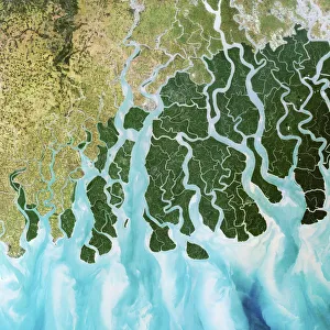
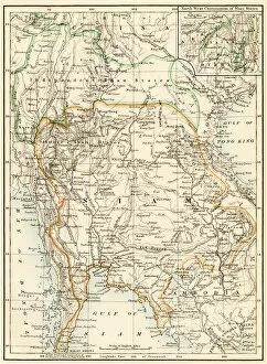
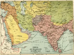
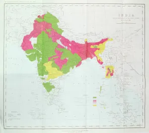
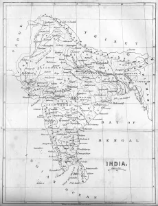
The Bay of Bengal, located in the eastern part of India and bordered by the Ganges River delta, is a captivating expanse that holds a wealth of natural beauty and historical significance. With its vast coastline stretching along countries like India and Bangladesh, this bay has been witness to countless stories throughout history. Gazing at an old map from 1902, we can see how Bengal's provinces were once divided, showcasing the region's rich heritage. A satellite image reveals the stunning coastal land that surrounds the bay, with its diverse ecosystems and breathtaking views. As dawn breaks at Mahabalipuram Coast, one can't help but be mesmerized by the tranquil beauty that unfolds before their eyes. The golden hues reflecting off the calm waters create a serene atmosphere that captivates both locals and visitors alike. Delving into history through antique engravings takes us back to significant events in this region. From Lord Mayo's unfortunate stabbing at Hope Town on Andaman Islands to daring rescue missions amidst wrecked ships in these treacherous waters - each engraving tells a tale of bravery and resilience. One such engraving transports us to Calcutta as it appeared centuries ago - bustling streets filled with life and activity. This glimpse into the past reminds us of how much this region has evolved over time while still preserving its cultural essence. The Bay of Bengal not only serves as a gateway for trade but also offers endless opportunities for exploration. Its azure waters beckon adventurers seeking thrilling experiences beneath its surface or those looking to relax on pristine beaches dotted along its shores. From ancient civilizations thriving along its banks to modern cities like Madras boasting new harbor works - this bay continues to shape lives and economies alike. It remains an integral part of South Asia's identity, connecting nations through shared histories and aspirations for progress. So next time you find yourself near this magnificent body of water known as the Bay of Bengal, take a moment to appreciate all that it represents.