Home > North America > United States of America > Wisconsin > Green Bay
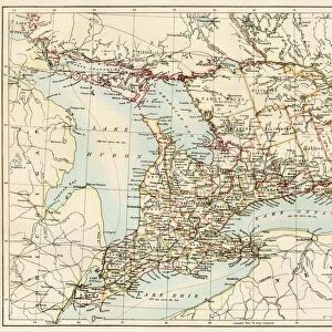
French settlement of the Great Lakes, 1600s

![]()
Wall Art and Photo Gifts from North Wind
French settlement of the Great Lakes, 1600s
French Jesuit map of Lake Superior, Upper Michigan, and Wisconsin, 1600s.
Hand-colored woodcut of a 17th-century illustration
North Wind Picture Archives brings history to life with stock images and hand-colored illustrations
Media ID 5880896
© North Wind Picture Archives
1600s 17th Century America Canada Canadian Chart Colonial Colony Discover Discovery Exploration Explore Explorer Fort French French Canada Frontier Great Lakes Jacques Marquette Jesuit Joliet Lake Michigan Lake Superior Louis Joliet Marquette Marquette And Joliet Michigan Mission Missionary New France Ontario Quebec Settlement Town Village Wild Wilderness Wisconsin Green Bay Lake Huron Sault Sainte Marie
FEATURES IN THESE COLLECTIONS
> Europe
> France
> Lakes
> Related Images
> North America
> Canada
> Lakes
> Lake Huron
> North America
> Canada
> Lakes
> Lake Superior
> North America
> Canada
> Maps
> North America
> United States of America
> Wisconsin
> Green Bay
> North Wind Picture Archives
> Exploration
> North Wind Picture Archives
> Maps
EDITORS COMMENTS
This print takes us back in time to the French settlement of the Great Lakes region during the 1600s. The hand-colored woodcut showcases a 17th-century illustration, depicting the vastness and beauty of Lake Superior, Upper Michigan, and Wisconsin. The image transports us to a bygone era when America was still a wild and untamed frontier. It captures the essence of this historic period, showcasing a village or town nestled amidst the wilderness. The scene evokes feelings of nostalgia as we imagine what life must have been like for early settlers in this remote part of North America. The map serves as both an exploration tool and missionary guide, highlighting important landmarks such as forts, missions, and settlements established by Jesuit missionaries. These brave explorers ventured into uncharted territories with hopes of spreading their faith while also establishing French colonies. One cannot help but marvel at the courage and determination displayed by these pioneers who left their homeland behind to embark on an arduous journey across treacherous waters. Their efforts paved the way for future generations to thrive in this new land. As we gaze upon this vintage piece of art representing New France's rich history, it reminds us that our heritage is deeply intertwined with those who came before us. This print offers a glimpse into our past—a visual testament to the spirit of discovery that shaped our continent's destiny.
MADE IN THE USA
Safe Shipping with 30 Day Money Back Guarantee
FREE PERSONALISATION*
We are proud to offer a range of customisation features including Personalised Captions, Color Filters and Picture Zoom Tools
SECURE PAYMENTS
We happily accept a wide range of payment options so you can pay for the things you need in the way that is most convenient for you
* Options may vary by product and licensing agreement. Zoomed Pictures can be adjusted in the Cart.