Home > Europe > Norway > Maps
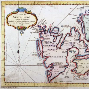
Map of the Faroe Island, c.1900 (engraving)
")
![]()
Wall Art and Photo Gifts from Fine Art Finder
Map of the Faroe Island, c.1900 (engraving)
533304 Map of the Faroe Island, c.1900 (engraving); (add.info.: Map of Faroe Island, circa 1902, from the 10th edition of Encyclopaedia Britannica.); Encyclopaedia Britannica/UIG
Media ID 38140610
© Encyclopaedia Britannica/UIG / Bridgeman Images
1902 19th Century Style Archipelago Atlantic Ocean Cut Out Guidance Illustration Technique Meridian Navigational Equipment Number Old Fashioned Physical Geography The Past Western Script White Background Faroe Island Norwegian Sea
FEATURES IN THESE COLLECTIONS
> Europe
> Norway
> Related Images
> Fine Art Finder
> Temp Classification
> Maps and Charts
> Related Images
EDITORS COMMENTS
This stunning vintage engraving of a Map of the Faroe Islands, dating back to around 1900, captures the intricate details and charm of cartography from the past. The map, sourced from the 10th edition of Encyclopaedia Britannica, showcases the archipelago's rugged coastline and unique geography in a style reminiscent of 19th-century exploration.
The Faroe Islands, situated in the Norwegian Sea between Iceland and Norway, are depicted with precision and artistry on this old-fashioned map. Navigational equipment symbols dot the landscape, guiding viewers through this remote island chain with historical flair.
With its Western script labels and meridians marking out coordinates against a clean white background, this engraving is not just a navigational tool but also a work of art. The illustration technique used to create this piece brings to life an era when maps were essential tools for discovery and exploration.
As you study this detailed depiction of the Faroe Islands from over a century ago, you can almost feel yourself transported back in time to an age when cartographers meticulously crafted maps by hand. This print is not just a representation of physical geography; it is a window into history itself.
MADE IN THE USA
Safe Shipping with 30 Day Money Back Guarantee
FREE PERSONALISATION*
We are proud to offer a range of customisation features including Personalised Captions, Color Filters and Picture Zoom Tools
SECURE PAYMENTS
We happily accept a wide range of payment options so you can pay for the things you need in the way that is most convenient for you
* Options may vary by product and licensing agreement. Zoomed Pictures can be adjusted in the Cart.