Home > Europe > United Kingdom > England > London > Towns > North End
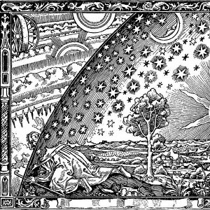
Map of the Cittie of London, 1633 (hand-coloured engraving)
")
![]()
Wall Art and Photo Gifts from Fine Art Finder
Map of the Cittie of London, 1633 (hand-coloured engraving)
495412 Map of the Cittie of London, 1633 (hand-coloured engraving) by Ryther, Augustus (fl.1572-92) (atrr. to); Private Collection; (add.info.: This plan was produced to satisfy a European market, and contains certain inaccuracies which a native Londoner would not have tolerated. The streets appear very much wider than they were in actuality. Houses are depicted as having large gardens, when these had, in fact, begun to disappear from London two centuries before. The map details the gap at the north end of London Bridge, caused by a fire in 1632.); English, out of copyright
Media ID 18256299
© Private Collection / Bridgeman Images
Aldgate Bankside Capital Cartographic Cartography Cheapside London Bridge London Wall Thames Inaccurate
FEATURES IN THESE COLLECTIONS
> Animals
> Insects
> Spiders
> European Garden
> Arts
> Artists
> Related Images
> Arts
> Landscape paintings
> Waterfall and river artworks
> River artworks
> Arts
> Portraits
> Pop art gallery
> Street art portraits
> Europe
> United Kingdom
> England
> London
> River Thames
> Europe
> United Kingdom
> England
> London
> Towns
> North End
> Europe
> United Kingdom
> England
> Maps
> Europe
> United Kingdom
> England
> Rivers
EDITORS COMMENTS
This hand-coloured engraving, titled "Map of the Cittie of London, 1633" takes us on a journey back in time to the bustling streets and winding alleys of historic London. Created by Augustus Ryther, or possibly attributed to him, this map was intended for a European audience and therefore contains certain inaccuracies that would have been unacceptable to native Londoners. As we examine the intricacies of this map, we notice that the streets appear much wider than they actually were during that era. The houses depicted boast expansive gardens, although these had long vanished from the cityscape two centuries prior. One notable feature is the gap at the north end of London Bridge caused by a devastating fire in 1632. The cartographic details are meticulous as it highlights prominent landmarks such as St. Paul's Church Yard and Aldgate while tracing along the meandering path of River Thames. It offers an intriguing glimpse into what life must have been like in England's capital city over three centuries ago. While some may criticize its inaccuracies, this map serves as a valuable historical artifact capturing both architectural features and urban layout from a specific moment in time. Its charm lies not only in its artistic representation but also in its ability to transport us back to an era when London was still evolving into what it is today – a vibrant metropolis with rich history and culture. Image credit: www. bridgemanimages. com
MADE IN THE USA
Safe Shipping with 30 Day Money Back Guarantee
FREE PERSONALISATION*
We are proud to offer a range of customisation features including Personalised Captions, Color Filters and Picture Zoom Tools
SECURE PAYMENTS
We happily accept a wide range of payment options so you can pay for the things you need in the way that is most convenient for you
* Options may vary by product and licensing agreement. Zoomed Pictures can be adjusted in the Cart.