Home > Aerial Photography > Italy
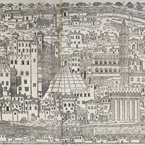
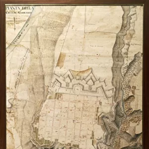
Ferrara at the time of the Marquis Nicolo Zoppo d Este, 1338

![]()
Wall Art and Photo Gifts from Universal Images Group (UIG)
Ferrara at the time of the Marquis Nicolo Zoppo d Este, 1338
Cartography, Italy, 17th century. Ferrara at the time of the Marquis NicolA
Universal Images Group (UIG) manages distribution for many leading specialist agencies worldwide
Media ID 9571893
© DEA / A. DE GREGORIO
14th Century Aerial View Ferrara Field Guidance Human Settlement Navigational Equipment Rural Scene Text 1338 Non Urban Scene
FEATURES IN THESE COLLECTIONS
> Architecture
> Country
> Italy
> Related Images
> Arts
> Art Movements
> Landscapes
> Arts
> Contemporary art
> Landscapes
> Sculptures
> Arts
> Contemporary art
> Sculpture
> Landscape paintings
> Arts
> Landscape paintings
> Landscape art
> Landscape paintings
> Arts
> Landscape paintings
> Landscape art
> Nature-inspired artwork
> Arts
> Landscape paintings
> Landscape art
> Arts
> Landscape paintings
> Nature-inspired artwork
> Universal Images Group (UIG)
> Art
> Painting, Sculpture & Prints
> Cartography
EDITORS COMMENTS
This print takes us back in time to the year 1338, when Marquis Nicolo Zoppo d Este ruled over Ferrara. The intricate cartography of this 17th-century Italian artwork beautifully depicts the topography and landscape of rural Ferrara during that era. From a bird's-eye view, we are able to explore the architectural marvels and human settlements that once thrived in this historical city. The artistry behind this engraved image is truly remarkable, as it showcases the skillful craftsmanship of its creator. With no people present in the scene, our focus is solely on the magnificent buildings and structures that shaped Ferrara's past. This horizontal composition allows us to fully immerse ourselves in this non-urban setting, appreciating every detail with clarity. As we gaze upon this piece, we can't help but feel a sense of wonderment at how navigational equipment was used during those times to map out such precise locations. It serves as a testament to humanity's desire for exploration and understanding of their surroundings. Whether you're an avid history enthusiast or simply appreciate fine art, this print offers a unique glimpse into Ferrara's rich heritage. Let your imagination wander through time as you delve into the beauty and intricacies captured within these ancient walls.
MADE IN THE USA
Safe Shipping with 30 Day Money Back Guarantee
FREE PERSONALISATION*
We are proud to offer a range of customisation features including Personalised Captions, Color Filters and Picture Zoom Tools
SECURE PAYMENTS
We happily accept a wide range of payment options so you can pay for the things you need in the way that is most convenient for you
* Options may vary by product and licensing agreement. Zoomed Pictures can be adjusted in the Cart.