Home > Europe > France > Canton > Vaucluse
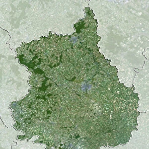
Departement of Vaucluse, France, Relief Map

![]()
Wall Art and Photo Gifts from Universal Images Group (UIG)
Departement of Vaucluse, France, Relief Map
Relief map of the departement of Vaucluse, France. It includes the Mont Ventoux to the northeast. This image was compiled from data acquired by LANDSAT 5 & 7 satellites combined with elevation data
Universal Images Group (UIG) manages distribution for many leading specialist agencies worldwide
Media ID 9633963
© Planet Observer
Geographical Border Mountain Provence Relief Map Luberon Mont Ventoux Satellite View Vaucluse
FEATURES IN THESE COLLECTIONS
> Europe
> France
> Canton
> Vaucluse
> Universal Images Group (UIG)
> Universal Images Group
> Satellite and Aerial
> Planet Observer 5
EDITORS COMMENTS
This print showcases the stunning relief map of the Departement of Vaucluse, France. With its intricate details and vibrant colors, it offers a unique perspective on the region's topography and physical geography. The map encompasses various elements that make Vaucluse truly remarkable. Stretching from Mont Ventoux in the northeast to Luberon in the south, this image provides an all-encompassing view of Vaucluse's diverse landscape. The majestic Mont Ventoux stands tall, dominating the horizon with its imposing presence. Its snow-capped peak serves as a reminder of nature's grandeur. The satellite data acquired by LANDSAT 5 & 7 satellites combined with elevation information has allowed for an accurate representation of this geographical marvel. Every contour and ridge is meticulously captured, offering viewers an immersive experience into Vaucluse's natural beauty. As you explore this relief map, you can trace the geographical borders that define Vaucluse within Provence, France. This horizontal composition allows for easy navigation across its vast expanse. With no people present in this photograph, your focus remains solely on appreciating Mother Nature's artistry at play. Whether you are a cartography enthusiast or simply intrigued by European landscapes, this print will undoubtedly captivate your imagination
MADE IN THE USA
Safe Shipping with 30 Day Money Back Guarantee
FREE PERSONALISATION*
We are proud to offer a range of customisation features including Personalised Captions, Color Filters and Picture Zoom Tools
SECURE PAYMENTS
We happily accept a wide range of payment options so you can pay for the things you need in the way that is most convenient for you
* Options may vary by product and licensing agreement. Zoomed Pictures can be adjusted in the Cart.