Home > Maps and Charts > Americas
Canvas Print : Columbus / Voyage Map


![]()
Canvas Prints from Mary Evans Picture Library
Columbus / Voyage Map
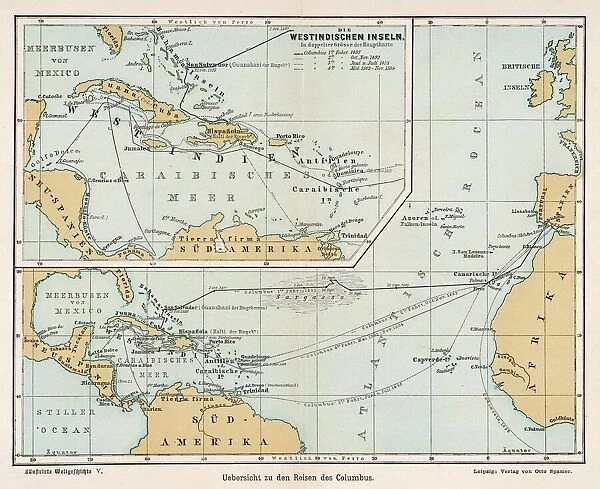
A map showing the voyages of Christopher Columbus
Mary Evans Picture Library makes available wonderful images created for people to enjoy over the centuries
Media ID 619778
© Mary Evans Picture Library 2015 - https://copyrighthub.org/s0/hub1/creation/maryevans/MaryEvansPictureID/10071306
Christopher Columbus Voyage Voyages
20"x16" (51x41cm) Canvas Print
Discover the rich history of exploration with our stunning Columbus / Voyage Map Canvas Print from the Media Storehouse collection, brought to you by Mary Evans Picture Library from Mary Evans Prints Online. This captivating image depicts the famous map detailing the voyages of Christopher Columbus, a testament to the spirit of discovery and adventure. The intricate lines and vibrant colors are beautifully rendered on a high-quality canvas, creating a stunning piece of art that adds character and depth to any room. Perfect for history enthusiasts or those who appreciate the beauty of vintage maps, this canvas print makes a unique and thoughtful gift. Bring the excitement of the past into your home today.
Delivered stretched and ready to hang our premium quality canvas prints are made from a polyester/cotton blend canvas and stretched over a 1.25" (32mm) kiln dried knot free wood stretcher bar. Packaged in a plastic bag and secured to a cardboard insert for safe transit.
Canvas Prints add colour, depth and texture to any space. Professionally Stretched Canvas over a hidden Wooden Box Frame and Ready to Hang
Estimated Product Size is 50.8cm x 40.6cm (20" x 16")
These are individually made so all sizes are approximate
Artwork printed orientated as per the preview above, with landscape (horizontal) orientation to match the source image.
FEATURES IN THESE COLLECTIONS
> Maps and Charts
> Early Maps
EDITORS COMMENTS
This historic map print, titled "Christopher Columbus' Voyages," is a captivating representation of the exploratory journeys undertaken by the Italian navigator, Christopher Columbus, during the late 15th century. The map, produced by an unknown cartographer, offers a fascinating glimpse into the early European understanding of the world and the groundbreaking discoveries made by Columbus and his crew. Columbus' first voyage, depicted in the map, began in 1492 when he set sail from Spain with three ships, the Santa Maria, the Pinta, and the Niña. Columbus' objective was to reach the East Indies by sailing westward across the Atlantic Ocean. Instead, he landed on an island in the Bahamas, marking the beginning of European exploration and eventual colonization of the Americas. The map illustrates Columbus' subsequent voyages, including his second voyage in 1493, during which he explored the Caribbean islands and made landfall in present-day Venezuela. His third voyage, in 1498, saw him discovering the islands of Trinidad and Tobago, and his final voyage in 1502, where he attempted to establish a settlement in present-day Honduras. The map's intricate details and vivid colors bring to life the excitement and adventure of Columbus' voyages, as well as the profound impact they had on world history. The map's historical significance lies not only in its depiction of Columbus' discoveries but also in its reflection of the evolving European perception of the world during this transformative period. This stunning map print is a must-have for history enthusiasts, educators, and anyone with an interest in the fascinating story of Christopher Columbus and the exploration of the New World.
MADE IN THE USA
Safe Shipping with 30 Day Money Back Guarantee
FREE PERSONALISATION*
We are proud to offer a range of customisation features including Personalised Captions, Color Filters and Picture Zoom Tools
SECURE PAYMENTS
We happily accept a wide range of payment options so you can pay for the things you need in the way that is most convenient for you
* Options may vary by product and licensing agreement. Zoomed Pictures can be adjusted in the Cart.