Home > Europe > Italy > Maps
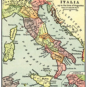
Canvas Print : Barbarossa-Era Italy Map


![]()
Canvas Prints from Mary Evans Picture Library
Barbarossa-Era Italy Map
A map of Italy in the reign of Holy Roman Emperor Friedrich I, known as Barbarossa
Mary Evans Picture Library makes available wonderful images created for people to enjoy over the centuries
Media ID 4344911
© Mary Evans Picture Library 2015 - https://copyrighthub.org/s0/hub1/creation/maryevans/MaryEvansPictureID/10139292
12th Barbarossa Friedrich Maps Reign
20"x16" (51x41cm) Canvas Print
Introducing the captivating Barbarossa-Era Italy Map Canvas Print from Media Storehouse. This exquisite piece of art transports you back in time, showcasing the Italian peninsula during the reign of Holy Roman Emperor Friedrich I, famously known as Barbarossa. Meticulously sourced from Mary Evans Prints Online, this rights managed image is brought to life in vibrant colors on high-quality canvas. Add an element of historical charm to your home or office decor with this stunning, large-format print. Experience the rich history of Italy like never before.
Delivered stretched and ready to hang our premium quality canvas prints are made from a polyester/cotton blend canvas and stretched over a 1.25" (32mm) kiln dried knot free wood stretcher bar. Packaged in a plastic bag and secured to a cardboard insert for safe transit.
Canvas Prints add colour, depth and texture to any space. Professionally Stretched Canvas over a hidden Wooden Box Frame and Ready to Hang
Estimated Product Size is 40.6cm x 50.8cm (16" x 20")
These are individually made so all sizes are approximate
Artwork printed orientated as per the preview above, with portrait (vertical) orientation to match the source image.
FEATURES IN THESE COLLECTIONS
> Maps and Charts
> Early Maps
> Maps and Charts
> Italy
EDITORS COMMENTS
This stunning print of a map depicting Italy during the reign of Holy Roman Emperor Friedrich I, also known as Barbarossa, offers a fascinating glimpse into 12th century history. The intricate details and historical significance of this map make it a valuable piece for any history enthusiast or collector.
During Barbarossa's rule, Italy was a complex and diverse region with various city-states and territories vying for power. This map showcases the political landscape of the time, highlighting key cities, regions, and borders that were crucial to understanding the dynamics of medieval Italy.
The vibrant colors and intricate cartography on display in this print bring to life an era filled with intrigue, conflict, and cultural exchange. From the bustling cities of Florence and Venice to the rugged terrain of Sicily and Sardinia, each corner of Italy is meticulously depicted on this map.
Whether you are a student studying European history or simply appreciate beautiful artwork with historical significance, this print is sure to captivate your imagination. Hang it in your home or office as a conversation starter or gift it to a friend who shares your passion for all things medieval.
Overall, this Barbarossa-era Italy map from Rights Managed is not just a decorative piece but also a window into an important period in Italian history that continues to fascinate scholars and enthusiasts alike.
MADE IN THE USA
Safe Shipping with 30 Day Money Back Guarantee
FREE PERSONALISATION*
We are proud to offer a range of customisation features including Personalised Captions, Color Filters and Picture Zoom Tools
SECURE PAYMENTS
We happily accept a wide range of payment options so you can pay for the things you need in the way that is most convenient for you
* Options may vary by product and licensing agreement. Zoomed Pictures can be adjusted in the Cart.