Home > Maps and Charts > Early Maps
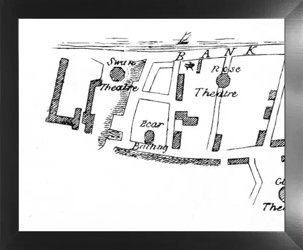
Framed Print : Bankside Map Theatres


![]()
Framed Photos from Mary Evans Picture Library
Bankside Map Theatres
A map of Bankside showing location of the theatres during the Elizabethan/ Jacobean period
Mary Evans Picture Library makes available wonderful images created for people to enjoy over the centuries
Media ID 604532
© Mary Evans Picture Library 2015 - https://copyrighthub.org/s0/hub1/creation/maryevans/MaryEvansPictureID/10050319
Bank Side C1600 Elizabethan Jacobean Theatres
22"x18" Modern Frame
Introducing the exquisite Framed Prints from Media Storehouse, featuring this captivating image of "Bankside Map Theatres" from Mary Evans Prints Online. This intricately detailed map transports you back to the Elizabethan and Jacobean periods, showcasing the location of the renowned theatres that once graced the banks of the River Thames in London. Each print is meticulously framed in a style that complements the historical essence of the image, making it a stunning addition to any home or office. Immerse yourself in the rich history of theatre and bring a piece of the past into your present with this beautiful Framed Print.
20x16 Print in an MDF Wooden Frame with 180 gsm Satin Finish Paper. Glazed using shatter proof thin plexiglass. Frame thickness is 1 inch and depth 0.75 inch. Fluted cardboard backing held with clips. Supplied ready to hang with sawtooth hanger and rubber bumpers. Spot clean with a damp cloth. Packaged foam wrapped in a card.
Contemporary Framed and Mounted Prints - Professionally Made and Ready to Hang
Estimated Image Size (if not cropped) is 50.8cm x 45.7cm (20" x 18")
Estimated Product Size is 55.9cm x 45.7cm (22" x 18")
These are individually made so all sizes are approximate
Artwork printed orientated as per the preview above, with landscape (horizontal) orientation to match the source image.
EDITORS COMMENTS
This fascinating print showcases a detailed map of Bankside during the Elizabethan and Jacobean period, highlighting the locations of various theatres that were integral to the cultural landscape of Britain in the 17th century. The intricate details on this map provide a glimpse into the historical significance of Bankside as a hub for theatrical performances and entertainment during this era.
The buildings depicted on this map represent iconic theatres that played host to some of Shakespeare's most famous works, as well as other renowned playwrights of the time. Each theatre marked on the map tells a story of creativity, innovation, and artistic expression that defined this period in British history.
As we study this image, we are transported back in time to an era where live performances captivated audiences and brought stories to life on stage. The architecture of these historic theatres is beautifully captured in this print, serving as a reminder of the rich cultural heritage that continues to influence modern-day theatre.
Whether you are a history enthusiast or simply appreciate the arts, this Bankside Map Theatres print is sure to spark curiosity and ignite your imagination as you explore the vibrant world of Elizabethan and Jacobean theatre.
MADE IN THE USA
Safe Shipping with 30 Day Money Back Guarantee
FREE PERSONALISATION*
We are proud to offer a range of customisation features including Personalised Captions, Color Filters and Picture Zoom Tools
SECURE PAYMENTS
We happily accept a wide range of payment options so you can pay for the things you need in the way that is most convenient for you
* Options may vary by product and licensing agreement. Zoomed Pictures can be adjusted in the Cart.