Home > Abstract Art > Painting > Related Images
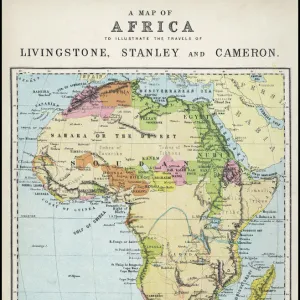
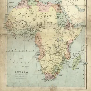
Part of the eastern coast of Africa with the Island of Madagascar and the detailed maps of the islands belonging to France and Bourbon, engraving by G. Zuliani taken from Tome IV of the "Newest Atlas" published in Venice in 1784 by Antonio Zatta, Private Collection

![]()
Wall Art and Photo Gifts from Fondazione Alinari per la Fotografia
Part of the eastern coast of Africa with the Island of Madagascar and the detailed maps of the islands belonging to France and Bourbon, engraving by G. Zuliani taken from Tome IV of the "Newest Atlas" published in Venice in 1784 by Antonio Zatta, Private Collection
Part of the eastern coast of Africa with the Island of Madagascar and the detailed maps of the islands belonging to France and Bourbon, engraving by G. Zuliani taken from Tome IV of the "Newest Atlas" published in Venice in 1784 by Antonio Zatta, Private Collection Florence Engraving Eighteenth Century, Renaissance-Baroque styles and periods, Europe, First and Second Millennium A.D.. Date of Photograph:2009. Date of Artwork:1784. Artist:Zuliani G
Alinari
PDP-A-ZATTA4-0019
Media ID 33189753
© Alinari Archives, Florence
Cartography Drawing And Graphics Geographical Or Topographical Map Geography Graphics Instrument And Document Islandeighteenth Century Scene Means Of Communication Territory Abstract Concept And Symbol Concept Or Subject Expressed
FEATURES IN THESE COLLECTIONS
> Abstract Art
> Painting
> Related Images
> Abstract Art
> Water
> Africa
> Madagascar
> Maps
> Africa
> Madagascar
> Related Images
> Arts
> Abstract art
> Arts
> Art Movements
> Baroque
> Arts
> Art Movements
> Renaissance Art
> Arts
> Still life artwork
> Abstract art
> Fine art
> Arts
> Minimalist artwork
> Abstract art
> Fine art
> Arts
> Modern art pieces
> Abstract art
> Fine art
EDITORS COMMENTS
This print showcases a remarkable engraving by G. Zuliani, taken from Tome IV of the "Newest Atlas" published in Venice in 1784 by Antonio Zatta. The print captures part of the eastern coast of Africa, featuring the majestic Island of Madagascar and detailed maps of islands belonging to France and Bourbon. The intricate craftsmanship and attention to detail in this engraving are truly awe-inspiring. Every line and curve meticulously etched onto the surface brings forth an exquisite representation of these geographical wonders. The Renaissance-Baroque styles employed by Zuliani transport us back to the Europe of the eighteenth century, evoking a sense of grandeur and sophistication. As we gaze upon this artwork, we are reminded not only of its aesthetic beauty but also its historical significance. This piece serves as both a means of communication and a valuable cartographic tool for understanding our world's geography during that era. The artist skillfully combines elements such as territory, allegory, abstract concepts, symbols, instruments, documents, seascape scenes into one cohesive composition. It is through this amalgamation that he successfully conveys his profound knowledge and passion for cartography. Dating back over two centuries ago to 1784 when it was created; this artwork has stood the test of time. Its preservation within private collections speaks volumes about its enduring value as a testament to human curiosity about our planet's vast landscapes. In capturing this photograph in 2009 with utmost precision and clarity; Alinari allows us to appreciate every minute detail present on this historic masterpiece today. Through their lens, they have immortalized an extraordinary work that continues to inspire wonderment among those who behold it.
MADE IN THE USA
Safe Shipping with 30 Day Money Back Guarantee
FREE PERSONALISATION*
We are proud to offer a range of customisation features including Personalised Captions, Color Filters and Picture Zoom Tools
SECURE PAYMENTS
We happily accept a wide range of payment options so you can pay for the things you need in the way that is most convenient for you
* Options may vary by product and licensing agreement. Zoomed Pictures can be adjusted in the Cart.